
Make a donation
Gear up for your next adventure:
As an Amazon Associate, this site earns from qualifying purchases at no extra cost to you.
Kalletal topographic map
Click on the map to display elevation.
Make a donation
Gear up for your next adventure:
As an Amazon Associate, this site earns from qualifying purchases at no extra cost to you.
Kalletal
Door het gemeentelijk grondgebied stroomt het riviertje de Kalle, die op 46 meter hoogte in het uiterste noordwesten in de Wezer uitmondt. De noordgrens van de gemeente is de rivier de Wezer (bij Erder, Varenholz en Stemmen).
Make a donation
Gear up for your next adventure:
As an Amazon Associate, this site earns from qualifying purchases at no extra cost to you.
About this map
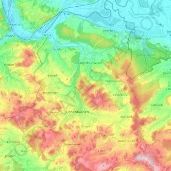
Name: Kalletal topographic map, elevation, terrain.
Location: Kalletal, Kreis Lippe, Noordrijn-Westfalen, 32689, Duitsland (52.06023 8.86408 52.19464 9.03776)
Average elevation: 175 m
Minimum elevation: 44 m
Maximum elevation: 384 m
Make a donation
Gear up for your next adventure:
As an Amazon Associate, this site earns from qualifying purchases at no extra cost to you.
Other topographic maps
Click on a map to view its topography, its elevation and its terrain.
Make a donation
Gear up for your next adventure:
As an Amazon Associate, this site earns from qualifying purchases at no extra cost to you.