
Thank you for supporting this site ❤️
Make a donation
Make a donation
Gear up for your next adventure:
As an Amazon Associate, this site earns from qualifying purchases at no extra cost to you.
Detmold topographic map
Click on the map to display elevation.
Thank you for supporting this site ❤️
Make a donation
Make a donation
Gear up for your next adventure:
As an Amazon Associate, this site earns from qualifying purchases at no extra cost to you.
About this map
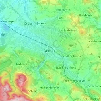
Name: Detmold topographic map, elevation, terrain.
Location: Detmold, Kreis Lippe, Noordrijn-Westfalen, 32756, Duitsland (51.89628 8.83915 51.97628 8.91915)
Average elevation: 183 m
Minimum elevation: 105 m
Maximum elevation: 401 m
Thank you for supporting this site ❤️
Make a donation
Make a donation
Gear up for your next adventure:
As an Amazon Associate, this site earns from qualifying purchases at no extra cost to you.