
Make a donation
Gear up for your next adventure:
As an Amazon Associate, this site earns from qualifying purchases at no extra cost to you.
Market Warsop topographic map
Click on the map to display elevation.
Make a donation
Gear up for your next adventure:
As an Amazon Associate, this site earns from qualifying purchases at no extra cost to you.
About this map
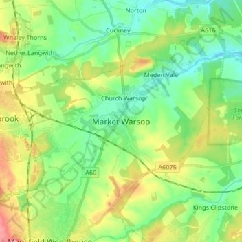
Name: Market Warsop topographic map, elevation, terrain.
Average elevation: 79 m
Minimum elevation: 42 m
Maximum elevation: 149 m
Make a donation
Gear up for your next adventure:
As an Amazon Associate, this site earns from qualifying purchases at no extra cost to you.
Other topographic maps
Click on a map to view its topography, its elevation and its terrain.
Manor House Pond
United Kingdom > England > Nottinghamshire > Broxtowe > Bramcote
Average elevation: 57 m
Make a donation
Gear up for your next adventure:
As an Amazon Associate, this site earns from qualifying purchases at no extra cost to you.
Sutton Lawn
United Kingdom > England > Nottinghamshire > Ashfield > Sutton-in-Ashfield
Average elevation: 155 m
Make a donation
Gear up for your next adventure:
As an Amazon Associate, this site earns from qualifying purchases at no extra cost to you.
Barton in Fabis
United Kingdom > England > Nottinghamshire > Rushcliffe > Barton-in-Fabis
Average elevation: 39 m
Make a donation
Gear up for your next adventure:
As an Amazon Associate, this site earns from qualifying purchases at no extra cost to you.
Sherwood Forest NNR
United Kingdom > England > Nottinghamshire > Newark and Sherwood > Ollerton > Edwinstowe CP
Average elevation: 71 m
Make a donation
Gear up for your next adventure:
As an Amazon Associate, this site earns from qualifying purchases at no extra cost to you.
Normanton on the Wolds
United Kingdom > England > Nottinghamshire > Rushcliffe
Average elevation: 59 m
Make a donation
Gear up for your next adventure:
As an Amazon Associate, this site earns from qualifying purchases at no extra cost to you.
Beckingham
United Kingdom > England > Nottinghamshire > Bassetlaw > Beckingham
Average elevation: 17 m
Make a donation
Gear up for your next adventure:
As an Amazon Associate, this site earns from qualifying purchases at no extra cost to you.
Balderton
United Kingdom > England > Nottinghamshire > Newark and Sherwood > Balderton
Average elevation: 20 m
Make a donation
Gear up for your next adventure:
As an Amazon Associate, this site earns from qualifying purchases at no extra cost to you.
Sutton in Ashfield
United Kingdom > England > Nottinghamshire > Ashfield > Stanton Hill
Average elevation: 154 m
Make a donation
Gear up for your next adventure:
As an Amazon Associate, this site earns from qualifying purchases at no extra cost to you.
Make a donation
Gear up for your next adventure:
As an Amazon Associate, this site earns from qualifying purchases at no extra cost to you.
Woodthorpe Grange Park
United Kingdom > England > Nottinghamshire > Nottingham > Arnold
Average elevation: 87 m
Make a donation
Gear up for your next adventure:
As an Amazon Associate, this site earns from qualifying purchases at no extra cost to you.
Staythorpe CP
United Kingdom > England > Nottinghamshire > Newark and Sherwood
The land is very low-lying and level, varying little in elevation between 12–14 metres (39–46 ft) throughout.
Average elevation: 16 m
Nottingham Canal
United Kingdom > England > Nottinghamshire > Nottingham > Beeston
Average elevation: 33 m
Make a donation
Gear up for your next adventure:
As an Amazon Associate, this site earns from qualifying purchases at no extra cost to you.
Kelham CP
United Kingdom > England > Nottinghamshire > Newark and Sherwood > Newark on Trent
Average elevation: 23 m
Make a donation
Gear up for your next adventure:
As an Amazon Associate, this site earns from qualifying purchases at no extra cost to you.
Willoughby on the Wolds
United Kingdom > England > Nottinghamshire > Rushcliffe
Average elevation: 92 m
Make a donation
Gear up for your next adventure:
As an Amazon Associate, this site earns from qualifying purchases at no extra cost to you.
River Meden
United Kingdom > England > Nottinghamshire > Mansfield > Warsop Vale
Average elevation: 71 m
Make a donation
Gear up for your next adventure:
As an Amazon Associate, this site earns from qualifying purchases at no extra cost to you.
Make a donation
Gear up for your next adventure:
As an Amazon Associate, this site earns from qualifying purchases at no extra cost to you.
Make a donation
Gear up for your next adventure:
As an Amazon Associate, this site earns from qualifying purchases at no extra cost to you.
Archers Lake
United Kingdom > England > Nottinghamshire > Rushcliffe > Bingham
Average elevation: 28 m
Make a donation
Gear up for your next adventure:
As an Amazon Associate, this site earns from qualifying purchases at no extra cost to you.
Collingham CP
United Kingdom > England > Nottinghamshire > Newark and Sherwood
Average elevation: 15 m
Make a donation
Gear up for your next adventure:
As an Amazon Associate, this site earns from qualifying purchases at no extra cost to you.
Make a donation
Gear up for your next adventure:
As an Amazon Associate, this site earns from qualifying purchases at no extra cost to you.
Sherwood Forest National Nature Reserve
United Kingdom > England > Nottinghamshire > Newark and Sherwood > Ollerton
Average elevation: 71 m
Make a donation
Gear up for your next adventure:
As an Amazon Associate, this site earns from qualifying purchases at no extra cost to you.
Elton-on-the-Hill
United Kingdom > England > Nottinghamshire > Rushcliffe
Elton lies about 14 miles (23 km) east of Nottingham. It straddles the A52 trunk road, from which Station Road runs north towards Orston and Sutton Lane south, with Sutton-cum-Granby being the nearest hamlet in that direction. Elton has a population of 114 people and is in the Rushcliffe district. It has an…
Average elevation: 29 m
Clipston
United Kingdom > England > Nottinghamshire > Rushcliffe
Clipston stands on the northernmost edge of the Wolds in Nottinghamshire. The area enjoys, from an elevation of about 79 m/259 ft, panoramic views of the Trent valley and the East and South side of the city of Nottingham, some 50 m/164 ft lower. Nearby to the west is Hoe Hill, with a horseshoe-shaped wood.
Average elevation: 59 m
Make a donation
Gear up for your next adventure:
As an Amazon Associate, this site earns from qualifying purchases at no extra cost to you.
Make a donation
Gear up for your next adventure:
As an Amazon Associate, this site earns from qualifying purchases at no extra cost to you.
Make a donation
Gear up for your next adventure:
As an Amazon Associate, this site earns from qualifying purchases at no extra cost to you.
North Muskham CP
United Kingdom > England > Nottinghamshire > Newark and Sherwood
Average elevation: 11 m
Newark
United Kingdom > England > Nottinghamshire > Newark and Sherwood > Newark on Trent
Average elevation: 17 m
Make a donation
Gear up for your next adventure:
As an Amazon Associate, this site earns from qualifying purchases at no extra cost to you.
Make a donation
Gear up for your next adventure:
As an Amazon Associate, this site earns from qualifying purchases at no extra cost to you.