
阳高县 topographic map
Interactive map
Click on the map to display elevation.
About this map
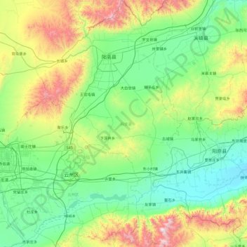
Name: 阳高县 topographic map, elevation, terrain.
Location: 阳高县, 大同市, 山西省, 中国 (39.83451 113.47854 40.51828 114.04239)
Average elevation: 1,222 m
Minimum elevation: 852 m
Maximum elevation: 2,401 m
Other topographic maps
Click on a map to view its topography, its elevation and its terrain.