Geolocate

Antoing topographic map

Click on the map to display elevation.

About this map
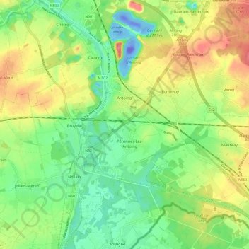
Name: Antoing topographic map, elevation, terrain.

Location: Antoing, Tournai-Mouscron, Hainaut, Wallonia, Belgium (50.52765 3.40792 50.58761 3.52868)

Average elevation: 36 m

Minimum elevation: -106 m

Maximum elevation: 83 m

Other topographic maps

Click on a map to view its topography, its elevation and its terrain.

Péruwelz

Belgium > Hainaut > Tournai-Mouscron

Average elevation: 36 m

Orcq

Belgium > Hainaut > Tournai-Mouscron

Average elevation: 43 m

Gear up for your next adventure:

🎁Outdoor Gift Ideas - Great gifts for adventurers
🪵Fire Starters & Tools - Tools to start fire in wet conditions
⛺Emergency Bivvy Bags - Life-saving heat-reflective shelter for emergencies
🔦UV Flashlights - Search for minerals or inspect maps at night
🌲Survival Gear - Equipment for outdoor survival situations

As an Amazon Associate, this site earns from qualifying purchases at no extra cost to you.