
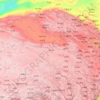
青海省 topographic map
Interactive map
Click on the map to display elevation.
About this map
Name: 青海省 topographic map, elevation, terrain.
Location: 青海省, 中国 (31.60180 89.40222 39.21423 103.06941)
Average elevation: 3,710 m
Minimum elevation: 787 m
Maximum elevation: 6,545 m
青海位于青藏高原东北部,全省均属高原范围之内。地形复杂,地貌多样。全省平均海拔3000多米,最高点昆仑山的布喀达板峰为6860米,最低点在民和下川口村,海拔为1650米。境内山脉高耸,地形多样,河流纵横,湖泊棋布。巍巍昆仑山横贯中部,唐古拉山峙立于南,祁连山矗立于北,茫茫草原起伏绵延,柴达木盆地浩瀚无限。长江、黄河及澜沧江(湄公河)(因此被称作“三江源”)之源头在青海。巴颜喀拉山为长江和黄河的分水岭。
Other topographic maps
Click on a map to view its topography, its elevation and its terrain.