
玄武湖街道 topographic map
Interactive map
Click on the map to display elevation.
About this map
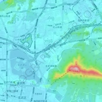
Name: 玄武湖街道 topographic map, elevation, terrain.
Location: 玄武湖街道, 玄武区, 南京市, 江苏省, 中国 (32.06668 118.81135 32.10544 118.90327)
Average elevation: 48 m
Minimum elevation: 7 m
Maximum elevation: 433 m
Other topographic maps
Click on a map to view its topography, its elevation and its terrain.
中国科学院紫金山天文台
中国科学院紫金山天文台, 天文台小道, 孝陵卫街道, 玄武区, 南京市, 江苏省, 210016, 中国
Average elevation: 89 m