
Brda topographic map
Interactive map
Click on the map to display elevation.
About this map
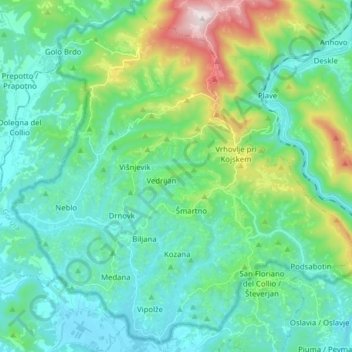
Name: Brda topographic map, elevation, terrain.
Location: Brda, Slovenia (45.96478 13.47616 46.06761 13.63240)
Average elevation: 211 m
Minimum elevation: 49 m
Maximum elevation: 809 m
Other topographic maps
Click on a map to view its topography, its elevation and its terrain.
Podgrad
The local parish church, built on a slight elevation on the edge of the village, is dedicated to the Our Lady of Good Counsel and belongs to the Roman Catholic Diocese of Novo Mesto. It was built in the early 17th century and extensively rebuilt in the 19th century.
Average elevation: 414 m