
Make a donation
Gear up for your next adventure:
As an Amazon Associate, this site earns from qualifying purchases at no extra cost to you.
Tivoli Terme topographic map
Click on the map to display elevation.
Make a donation
Gear up for your next adventure:
As an Amazon Associate, this site earns from qualifying purchases at no extra cost to you.
About this map
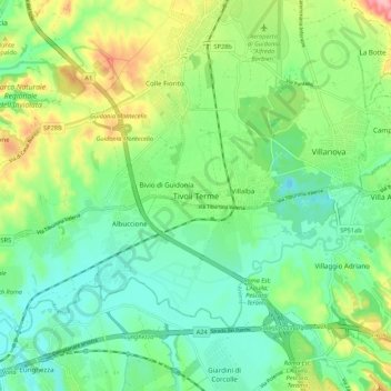
Name: Tivoli Terme topographic map, elevation, terrain.
Location: Tivoli Terme, Tivoli, Roma Capitale, Lazio, 00011, Italy (41.91446 12.67771 41.99446 12.75771)
Average elevation: 66 m
Minimum elevation: 20 m
Maximum elevation: 166 m
Make a donation
Gear up for your next adventure:
As an Amazon Associate, this site earns from qualifying purchases at no extra cost to you.
Other topographic maps
Click on a map to view its topography, its elevation and its terrain.
Rome
Italy > Lazio > Roma Capitale
Rome's topography is characterized by a series of distinct hills and the winding Tiber River, which has been pivotal to its historical development. The city is famously built on seven hills—Aventine, Caelian, Capitoline, Esquiline, Palatine, Quirinal, and Viminal—each offering unique vantage points and…
Average elevation: 123 m
Make a donation
Gear up for your next adventure:
As an Amazon Associate, this site earns from qualifying purchases at no extra cost to you.
Make a donation
Gear up for your next adventure:
As an Amazon Associate, this site earns from qualifying purchases at no extra cost to you.
Castello di Santa Severa
Italy > Lazio > Roma Capitale > Santa Marinella > Santa Severa
Average elevation: 5 m
Make a donation
Gear up for your next adventure:
As an Amazon Associate, this site earns from qualifying purchases at no extra cost to you.
Make a donation
Gear up for your next adventure:
As an Amazon Associate, this site earns from qualifying purchases at no extra cost to you.
Parco degli Acquedotti
Italy > Lazio > Roma Capitale > Rome > Osteria del Curato
Average elevation: 62 m
Villa d'Este
Italy > Lazio > Roma Capitale > Tivoli
Tivoli had been a popular summer residence since ancient Roman times due to its altitude, cooler temperatures and its proximity to the Villa Hadriana, the summer residence of the Emperor Hadrian I. The position of Governor of Tivoli came with an official residence located in a former convent of the Benedictine…
Average elevation: 203 m
Make a donation
Gear up for your next adventure:
As an Amazon Associate, this site earns from qualifying purchases at no extra cost to you.
Make a donation
Gear up for your next adventure:
As an Amazon Associate, this site earns from qualifying purchases at no extra cost to you.
Area di sosta turistica Info Point Appia Antica X-XI miglio
Italy > Lazio > Roma Capitale > Marino > Poggio delle Mole
Average elevation: 152 m
Make a donation
Gear up for your next adventure:
As an Amazon Associate, this site earns from qualifying purchases at no extra cost to you.
Make a donation
Gear up for your next adventure:
As an Amazon Associate, this site earns from qualifying purchases at no extra cost to you.
Make a donation
Gear up for your next adventure:
As an Amazon Associate, this site earns from qualifying purchases at no extra cost to you.
Velletri
Italy > Lazio > Roma Capitale
The old town's altitude is substantially uniform from the elevation of Piazza Giuseppe Garibaldi at 339 m above sea level, the square of the Trivium at 332 metres (1,089 feet) above sea level, and Napoletana at 329 metres (1,079 feet) above sea level. The area west of the walled city is a bit higher at San…
Average elevation: 226 m
Make a donation
Gear up for your next adventure:
As an Amazon Associate, this site earns from qualifying purchases at no extra cost to you.
Santa Marinella
Italy > Lazio > Roma Capitale
In antiquity, Santa Marinella was the site of Punicum, an important Etruscan port which served the city of Caere. Punicum was identified in the Peutinger Table, in which it is on the Via Aurelia 9km N of Pyrgi. The area had several scattered settlements in Etruscan times. It was near an easy landing point,…
Average elevation: 69 m
Make a donation
Gear up for your next adventure:
As an Amazon Associate, this site earns from qualifying purchases at no extra cost to you.
Make a donation
Gear up for your next adventure:
As an Amazon Associate, this site earns from qualifying purchases at no extra cost to you.
Make a donation
Gear up for your next adventure:
As an Amazon Associate, this site earns from qualifying purchases at no extra cost to you.
Make a donation
Gear up for your next adventure:
As an Amazon Associate, this site earns from qualifying purchases at no extra cost to you.
Make a donation
Gear up for your next adventure:
As an Amazon Associate, this site earns from qualifying purchases at no extra cost to you.
Velletri
Italy > Lazio > Roma Capitale
The old town's altitude is substantially uniform from the elevation of Piazza Giuseppe Garibaldi at 339 m above sea level, the square of the Trivium at 332 metres (1,089 feet) above sea level, and Napoletana at 329 metres (1,079 feet) above sea level. The area west of the walled city is a bit higher at San…
Average elevation: 226 m
Castel Gandolfo
Italy > Lazio > Roma Capitale
The maximum elevation registered in the territory is 425 m (1,390 ft) above sea level, at the Collegio di Propaganda Fide adjoining Villa Barberini. On the crown of the hills around the Lake Albano, the elevation is only 400 m (1,300 ft) above sea level, at the summit of Monte Cucco, bordering Marino.
Average elevation: 306 m
Make a donation
Gear up for your next adventure:
As an Amazon Associate, this site earns from qualifying purchases at no extra cost to you.