
Make a donation
Gear up for your next adventure:
As an Amazon Associate, this site earns from qualifying purchases at no extra cost to you.
Villa d'Este topographic map
Click on the map to display elevation.
Make a donation
Gear up for your next adventure:
As an Amazon Associate, this site earns from qualifying purchases at no extra cost to you.
Villa d'Este
Tivoli had been a popular summer residence since ancient Roman times due to its altitude, cooler temperatures and its proximity to the Villa Hadriana, the summer residence of the Emperor Hadrian I. The position of Governor of Tivoli came with an official residence located in a former convent of the Benedictine order, which had been built in the 9th century on the site of an old Roman villa. In 1256 it had been donated to the Franciscan order. The residence was not large enough for the enormous household of a Cardinal as prominent as d'Este, but it did have an extensive view of the countryside below, including Hadrian's villa, and an abundant natural water supply for fountains and gardens. D'Este commissioned a prominent classical scholar, Pirro Ligorio, who had studied the Villa Hadriana and other Roman sites in the vicinity, to plan a new villa and garden which would exceed anything the Romans had built. He obtained an abundant supply of marble and statuary from the ruins of Hadrian's villa.
Make a donation
Gear up for your next adventure:
As an Amazon Associate, this site earns from qualifying purchases at no extra cost to you.
About this map
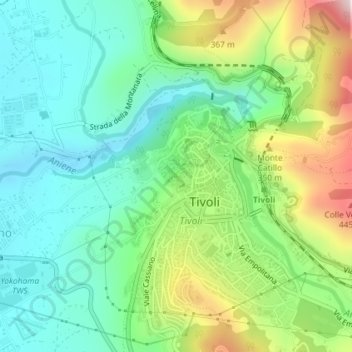
Name: Villa d'Este topographic map, elevation, terrain.
Location: Villa d'Este, Tivoli, Roma Capitale, Lazio, Italy (41.96158 12.79405 41.96422 12.79762)
Average elevation: 203 m
Minimum elevation: 51 m
Maximum elevation: 525 m
Make a donation
Gear up for your next adventure:
As an Amazon Associate, this site earns from qualifying purchases at no extra cost to you.
Other topographic maps
Click on a map to view its topography, its elevation and its terrain.