
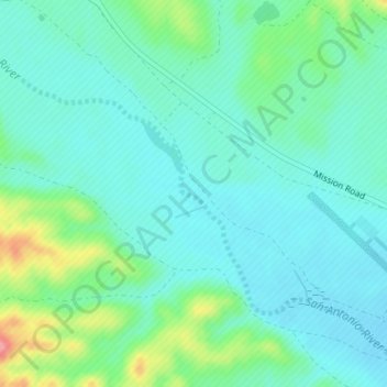
San Antonio River topographic map
Interactive map
Click on the map to display elevation.
About this map
Name: San Antonio River topographic map, elevation, terrain.
Average elevation: 310 m
Minimum elevation: 286 m
Maximum elevation: 390 m
Other topographic maps
Click on a map to view its topography, its elevation and its terrain.
Riverside
United States of America > California > Riverside
Riverside, Riverside County, California, United States of America
Average elevation: 351 m
Truckee
United States of America > California > Truckee
Truckee, Nevada County, California, United States of America
Average elevation: 1,917 m
Castro Valley
United States of America > California > Castro Valley
Castro Valley, Alameda County, California, 94546, United States of America
Average elevation: 86 m
Salton Sea
United States of America > California
Salton Sea, California, United States of America
Average elevation: 17 m
Beaumont
United States of America > California > Beaumont
Beaumont, Riverside County, California, 92223, United States of America
Average elevation: 725 m
Lake Elsinore
United States of America > California > Lake Elsinore
Lake Elsinore, Riverside County, California, United States of America
Average elevation: 531 m
San Clemente Island
United States of America > California
San Clemente Island, Los Angeles County, California, United States of America
Average elevation: 49 m
Lopez Lake
United States of America > California
Lopez Lake, Lopez Drive, San Luis Obispo County, California, 94320, United States of America
Average elevation: 249 m
Stahl House
United States of America > California > Los Angeles
Stahl House, 1635, Woods Drive, Hollywood Hills West, Los Angeles, Los Angeles County, California, 90046-2549, United States of America
Average elevation: 199 m
Eastvale
United States of America > California > Eastvale
Eastvale, Riverside County, California, 91752, United States of America
Average elevation: 204 m
Palmdale
United States of America > California > Palmdale
Palmdale, Los Angeles County, California, United States of America
Average elevation: 898 m
Port Hueneme
United States of America > California > Port Hueneme
Port Hueneme, Ventura County, California, 93043, United States of America
Average elevation: 4 m
San Francisco
United States of America > California
San Francisco, California, United States of America
Average elevation: 57 m
Topanga State Park
United States of America > California > Los Angeles
Topanga State Park, Paseo Miramar, Pacific Palisades, Los Angeles, Los Angeles County, California, 90272-3002, United States of America
Average elevation: 77 m
Beilenson Park / Lake Balboa Park
United States of America > California > Los Angeles
Beilenson Park / Lake Balboa Park, Lake Balboa, Los Angeles, California, United States of America
Average elevation: 222 m
Cheviot Hills
United States of America > California > Los Angeles
Cheviot Hills, Los Angeles, Los Angeles County, California, 90064-2320, United States of America
Average elevation: 62 m
Glendora
United States of America > California > Glendora
Glendora, Los Angeles County, California, United States of America
Average elevation: 344 m
Bolinas
United States of America > California > Bolinas
Bolinas, Hillside, Bolinas, Marin County, California, 94924, United States of America
Average elevation: 28 m
Loma Linda
United States of America > California > Loma Linda
Loma Linda, San Bernardino County, California, United States of America
Average elevation: 329 m
San Nicolas Island
United States of America > California
San Nicolas Island, Ventura County, California, United States of America
Average elevation: 38 m
Willow Glen South
United States of America > California > San Jose
Willow Glen South, San Jose, Santa Clara County, California, United States of America
Average elevation: 49 m
Mare Island
United States of America > California > Vallejo
Mare Island, Vallejo, Solano County, California, 94592, United States of America
Average elevation: 108 m
Malibu Creek State Park
United States of America > California > Monte Nido
Malibu Creek State Park, Monte Nido, Los Angeles County, California, United States of America
Average elevation: 275 m
El Sobrante
United States of America > California > Richmond
El Sobrante, Oil Well Trail, Richmond, Contra Costa County, California, 9480, United States of America
Average elevation: 79 m
Lake George
United States of America > California > Mammoth Lakes > Lake Mary
Lake George, Lake George Road, Lake Mary, Mammoth Lakes, Mono County, California, United States of America
Average elevation: 2,850 m
Mount Fiji
United States of America > California > Los Angeles
Mount Fiji, Los Angeles, Los Angeles County, California, 90041, United States of America
Average elevation: 191 m
Hollywood Riviera
United States of America > California > Hollywood Riviera
Hollywood Riviera, Los Angeles County, California, 90277-5906, United States of America
Average elevation: 50 m
Nevada City
United States of America > California > Nevada City
Nevada City, Nevada County, California, 95959, United States of America
Average elevation: 810 m
Arcata
United States of America > California > Arcata
Arcata, Humboldt County, California, United States of America
Average elevation: 82 m
Fort Jones
United States of America > California > Fort Jones
Fort Jones, Siskiyou County, California, 96032, United States of America
Average elevation: 896 m
Canyon Crest
United States of America > California > Riverside > Canyon Crest
Canyon Crest, Riverside, Riverside County, California, 92507, United States of America
Average elevation: 372 m
La Cresta Highlands
United States of America > California > La Cresta Highlands
La Cresta Highlands, Riverside County, California, United States of America
Average elevation: 695 m
Scotts Corner
United States of America > California > Scotts Corner
Scotts Corner, Alameda County, California, 94586, United States of America
Average elevation: 115 m
Happy Valley
United States of America > California > Happy Valley
Happy Valley, Calaveras County, California, United States of America
Average elevation: 434 m
Point Mugu State Park
United States of America > California
Point Mugu State Park, Ventura County, California, United States of America
Average elevation: 158 m
Boulder Creek
United States of America > California
Boulder Creek, San Diego County, California, United States of America
Average elevation: 800 m
Lake Davis
United States of America > California > Delleker
Lake Davis, Deerweed, Delleker, Plumas County, California, 96122, United States of America
Average elevation: 1,676 m
Red Rock Canyon State Park
United States of America > California > Ricardo
Red Rock Canyon State Park, Ricardo, Kern County, California, United States of America
Average elevation: 891 m
Grant Lake
United States of America > California
Grant Lake, Halls Valley Trail, Santa Clara County, California, 95140, United States of America
Average elevation: 556 m
Skyline Ranch
United States of America > California > Skyline Ranch
Skyline Ranch, Santa Cruz County, California, 95007, United States of America
Average elevation: 535 m
West Covina
United States of America > California > West Covina
West Covina, Los Angeles County, California, United States of America
Average elevation: 130 m
Fish Camp
United States of America > California > Fish Camp
Fish Camp, Mariposa County, California, United States of America
Average elevation: 1,618 m
Clipper Gap
United States of America > California > Clipper Gap
Clipper Gap, Placer County, California, 95703, United States of America
Average elevation: 534 m
Crafton
United States of America > California > Mentone > Crafton
Crafton, Mentone, San Bernardino County, California, 92359, United States of America
Average elevation: 557 m
Oasis
United States of America > California > Oasis
Oasis, California, 92274, United States of America
Average elevation: -39 m
Del Mar
United States of America > California > Del Mar
Del Mar, San Diego County, California, United States of America
Average elevation: 24 m
China Peak
United States of America > California
China Peak, Yolo County, California, 95637, United States of America
Average elevation: 290 m
El Verano
United States of America > California > El Verano
El Verano, Sonoma County, California, United States of America
Average elevation: 40 m
Maricopa
United States of America > California > Maricopa
Maricopa, Kern County, California, United States of America
Average elevation: 278 m
Corona
United States of America > California > Corona
Corona, Riverside County, California, United States of America
Average elevation: 377 m