
Topanga State Park topographic map
Interactive map
Click on the map to display elevation.
About this map
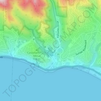
Name: Topanga State Park topographic map, elevation, terrain.
Average elevation: 77 m
Minimum elevation: 0 m
Maximum elevation: 347 m
Other topographic maps
Click on a map to view its topography, its elevation and its terrain.
Stahl House
United States of America > California > Los Angeles
Stahl House, 1635, Woods Drive, Hollywood Hills West, Los Angeles, Los Angeles County, California, 90046-2549, United States of America
Average elevation: 199 m
Beilenson Park / Lake Balboa Park
United States of America > California > Los Angeles
Beilenson Park / Lake Balboa Park, Lake Balboa, Los Angeles, California, United States of America
Average elevation: 222 m
Cheviot Hills
United States of America > California > Los Angeles
Cheviot Hills, Los Angeles, Los Angeles County, California, 90064-2320, United States of America
Average elevation: 62 m
Mount Fiji
United States of America > California > Los Angeles
Mount Fiji, Los Angeles, Los Angeles County, California, 90041, United States of America
Average elevation: 191 m