
Waukesha County topographic map
Interactive map
Click on the map to display elevation.
About this map
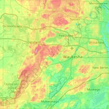
Name: Waukesha County topographic map, elevation, terrain.
Location: Waukesha County, Wisconsin, USA (42.84195 -88.54216 43.19608 -88.06334)
Average elevation: 272 m
Minimum elevation: 222 m
Maximum elevation: 369 m
Other topographic maps
Click on a map to view its topography, its elevation and its terrain.
Dodgeville
USA > Wisconsin > Dodgeville
Dodgeville, Iowa County, Wisconsin, USA
Average elevation: 370 m
Clare Island
USA > Wisconsin > Lake Delton
Clare Island, Lake Delton, Sauk County, Wisconsin, 53940, USA
Average elevation: 288 m
Gays Mills
USA > Wisconsin > Gays Mills
Gays Mills, Crawford County, Wisconsin, USA
Average elevation: 272 m
WEVR-AM (River Falls)
WEVR-AM (River Falls), Radio Road, Glover, Town of Troy, Saint Croix County, Wisconsin, 54022, USA
Average elevation: 301 m