
Make a donation
Gear up for your next adventure:
As an Amazon Associate, this site earns from qualifying purchases at no extra cost to you.
Windsor topographic map
Click on the map to display elevation.
Make a donation
Gear up for your next adventure:
As an Amazon Associate, this site earns from qualifying purchases at no extra cost to you.
About this map
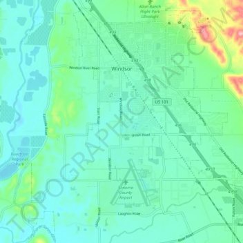
Name: Windsor topographic map, elevation, terrain.
Location: Windsor, Sonoma County, California, 95492, United States (38.49230 -122.86114 38.56740 -122.77247)
Average elevation: 39 m
Minimum elevation: 8 m
Maximum elevation: 161 m
Make a donation
Gear up for your next adventure:
As an Amazon Associate, this site earns from qualifying purchases at no extra cost to you.
Other topographic maps
Click on a map to view its topography, its elevation and its terrain.
Make a donation
Gear up for your next adventure:
As an Amazon Associate, this site earns from qualifying purchases at no extra cost to you.
Park Creek Village Mobile Home Park
United States > California > Sonoma County > Sonoma
Average elevation: 36 m