
Cortland County topographic map
Interactive map
Click on the map to display elevation.
About this map
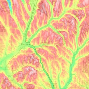
Name: Cortland County topographic map, elevation, terrain.
Location: Cortland County, New York, United States (42.40765 -76.27460 42.79104 -75.86416)
Average elevation: 453 m
Minimum elevation: 261 m
Maximum elevation: 648 m
Other topographic maps
Click on a map to view its topography, its elevation and its terrain.
Manhattan
United States > New York > New York County > New York
Manhattan, New York County, New York, United States
Average elevation: 16 m
Brooklyn
United States > New York > New York
Brooklyn, Kings County, New York, United States
Average elevation: 9 m
City of Syracuse
United States > New York > Onondaga County
City of Syracuse, Onondaga County, New York, United States
Average elevation: 172 m
Adirondack Park
Adirondack Park, New York, United States
Average elevation: 371 m
Stevens Landing
United States > New York > Clinton County > Town of Black Brook
Stevens Landing, Town of Black Brook, Clinton County, New York, 12912, United States
Average elevation: 385 m
City of Schenectady
United States > New York > Schenectady County
City of Schenectady, Schenectady County, New York, 12345, United States
Average elevation: 100 m
Rensselaer County
Rensselaer County, New York, United States
Average elevation: 239 m
City of Rye
United States > New York > Westchester County
City of Rye, Westchester County, New York, United States
Average elevation: 9 m
East Hampton
United States > New York > Suffolk County > East Hampton > Village of East Hampton
East Hampton, Village of East Hampton, Suffolk County, New York, 11937, United States
Average elevation: 12 m
Town of Clifton Park
United States > New York > Saratoga County
Town of Clifton Park, Saratoga County, New York, United States
Average elevation: 85 m
Buffalo
United States > New York > Erie County
Buffalo, Erie County, New York, United States
Average elevation: 185 m
North Boston
United States > New York > Erie County > Town of Boston
North Boston, Town of Boston, Erie County, New York, United States
Average elevation: 305 m
Town of Huntington
United States > New York > Suffolk County
Town of Huntington, Suffolk County, New York, United States
Average elevation: 30 m
Town of Catskill
United States > New York > Greene County
Town of Catskill, Greene County, New York, United States
Average elevation: 59 m
Finger Lakes National Forest
United States > New York > Schuyler County > Town of Hector
Finger Lakes National Forest, Town of Hector, Schuyler County, New York, 14818, United States
Average elevation: 356 m
Manhattan Island
United States > New York > New York
Manhattan Island, New York, United States
Average elevation: 17 m
Central Park
United States > New York > New York County > New York
Central Park, New York County, New York, United States
Average elevation: 26 m
Village of Scarsdale
United States > New York > Westchester County
Village of Scarsdale, Westchester County, New York, 10583, United States
Average elevation: 76 m
City of Ithaca
United States > New York > Tompkins County
City of Ithaca, Tompkins County, New York, United States
Average elevation: 195 m
Staten Island
United States > New York > New York
Staten Island, Richmond County, New York, United States
Average elevation: 9 m
Saratoga County
Saratoga County, New York, United States
Average elevation: 218 m
Columbia County
Columbia County, New York, United States
Average elevation: 196 m
Roosevelt Island
United States > New York > New York County > New York
Roosevelt Island, Manhattan, New York County, New York, 10044, United States
Average elevation: 13 m
Drayton Grant Park at Burger Hill
United States > New York > Dutchess County > Town of Rhinebeck
Drayton Grant Park at Burger Hill, Town of Rhinebeck, Dutchess County, New York, United States
Average elevation: 102 m
Lake George
United States > New York > Warren County > Town of Bolton
Lake George, Town of Bolton, Warren County, New York, United States
Average elevation: 247 m
Upper West Side
United States > New York > New York
Upper West Side, Manhattan Community Board 7, Manhattan, New York County, New York, United States
Average elevation: 23 m
The Bronx
United States > New York > New York
The Bronx, New York, United States
Average elevation: 23 m
Westchester County
Westchester County, New York, United States
Average elevation: 95 m
City of Binghamton
United States > New York > Broome County
City of Binghamton, Dickinson, Broome County, New York, 13905, United States
Average elevation: 321 m
City of Troy
United States > New York > Rensselaer County
City of Troy, Rensselaer County, New York, United States
Average elevation: 81 m
Troy
United States > New York > Rensselaer County
Troy, Rensselaer County, New York, 12181, United States
Average elevation: 137 m
Dutchess County
Dutchess County, New York, United States
Average elevation: 179 m
Bush Terminal Park
United States > New York > New York
Bush Terminal Park, Brooklyn, Kings County, New York, United States
Average elevation: 8 m
Tompkins County
Tompkins County, New York, United States
Average elevation: 377 m
Great Neck Gardens
United States > New York > Nassau County
Great Neck Gardens, Town of North Hempstead, Nassau County, New York, United States
Average elevation: 27 m
Village of Tuckahoe
United States > New York > Westchester County > Town of Eastchester
Village of Tuckahoe, Town of Eastchester, Westchester County, New York, United States
Average elevation: 57 m
Montauk
United States > New York > Suffolk County > Town of East Hampton
Montauk, Town of East Hampton, Suffolk County, New York, 11954, United States
Average elevation: 2 m
Town of Wayne
United States > New York > Steuben County
Town of Wayne, Steuben County, New York, 14893, United States
Average elevation: 369 m
Saratoga Springs
United States > New York > Saratoga County > Saratoga Springs
Saratoga Springs, City of Saratoga Springs, Saratoga County, New York, 12866, United States
Average elevation: 161 m
City of Yonkers
United States > New York > Westchester County
City of Yonkers, Westchester County, New York, United States
Average elevation: 58 m