
City of Ithaca topographic map
Interactive map
Click on the map to display elevation.
About this map
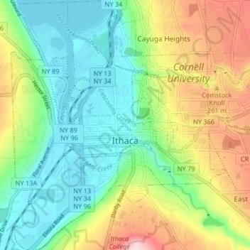
Name: City of Ithaca topographic map, elevation, terrain.
Location: City of Ithaca, Tompkins County, New York, United States (42.41817 -76.52700 42.46694 -76.46999)
Average elevation: 195 m
Minimum elevation: 112 m
Maximum elevation: 347 m
Other topographic maps
Click on a map to view its topography, its elevation and its terrain.
Cass Park
United States > New York > Tompkins County > City of Ithaca
Cass Park, 701, Ward 1, City of Ithaca, Tompkins County, New York, 14850, United States
Average elevation: 156 m
West Groton
United States > New York > Tompkins County > Town of Groton
West Groton, Town of Groton, Tompkins County, New York, 13092, United States
Average elevation: 375 m
Terpening Corners
United States > New York > Tompkins County > South Lansing
Terpening Corners, South Lansing, Town of Lansing, Tompkins County, New York, United States
Average elevation: 288 m
Village of Freeville
United States > New York > Tompkins County
Village of Freeville, Town of Dryden, Tompkins County, New York, United States
Average elevation: 322 m
Northeast Ithaca
United States > New York > Tompkins County > Town of Ithaca
Northeast Ithaca, Town of Ithaca, Tompkins County, New York, United States
Average elevation: 305 m
Hayts Corner
United States > New York > Tompkins County > Town of Ithaca
Hayts Corner, Town of Ithaca, Tompkins County, New York, 14851, United States
Average elevation: 256 m
Town of Lansing
United States > New York > Tompkins County
Town of Lansing, Tompkins County, New York, 14882, United States
Average elevation: 308 m
Shindagin Hollow State Forest
United States > New York > Tompkins County > Town of Caroline
Shindagin Hollow State Forest, Town of Caroline, Tompkins County, New York, United States
Average elevation: 457 m
Caroline Depot
United States > New York > Tompkins County > Town of Caroline
Caroline Depot, Town of Caroline, Tompkins County, New York, 14817, United States
Average elevation: 368 m
Town of Newfield
United States > New York > Tompkins County
Town of Newfield, Tompkins County, New York, 14867, United States
Average elevation: 426 m
Brooktondale
United States > New York > Tompkins County
Brooktondale, Town of Caroline, Tompkins County, New York, United States
Average elevation: 323 m
Town of Ithaca
United States > New York > Tompkins County
Town of Ithaca, Tompkins County, New York, United States
Average elevation: 288 m
Danby State Forest
United States > New York > Tompkins County > Town of Danby
Danby State Forest, Town of Danby, Tompkins County, New York, United States
Average elevation: 417 m
Village of Groton
United States > New York > Tompkins County
Village of Groton, Town of Groton, Tompkins County, New York, United States
Average elevation: 361 m
Ithaca
United States > New York > Tompkins County > Ithaca
Ithaca, Ithaca Town, Tompkins County, New York, 14850, United States
Average elevation: 370 m
Speedsville
United States > New York > Tompkins County > Town of Caroline
Speedsville, Town of Caroline, Tompkins County, New York, United States
Average elevation: 400 m
Village of Cayuga Heights
United States > New York > Tompkins County > Town of Ithaca > Village of Cayuga Heights
Village of Cayuga Heights, Town of Ithaca, Tompkins County, New York, United States
Average elevation: 234 m
Town of Dryden
United States > New York > Tompkins County
Town of Dryden, Tompkins County, New York, United States
Average elevation: 430 m
Village of Trumansburg
United States > New York > Tompkins County
Village of Trumansburg, Town of Ulysses, Tompkins County, New York, 14854, United States
Average elevation: 300 m
Lansing
United States > New York > Tompkins County > Lansing > Lansing
Lansing, Lansing Town, Tompkins County, New York, 14853, United States
Average elevation: 262 m
Caroline
United States > New York > Tompkins County > Caroline
Caroline, Caroline Town, Tompkins County, New York, United States
Average elevation: 462 m
East Ithaca
United States > New York > Tompkins County > Ithaca > East Ithaca
East Ithaca, Ithaca, Ithaca Town, Tompkins County, New York, 14853, United States
Average elevation: 234 m
Village of Lansing
United States > New York > Tompkins County
Village of Lansing, Town of Lansing, Tompkins County, New York, United States
Average elevation: 294 m
Varna
United States > New York > Tompkins County > Varna
Varna, Dryden Town, Tompkins County, New York, 14853, United States
Average elevation: 319 m