
Bihar topographic map
Interactive map
Click on the map to display elevation.
About this map
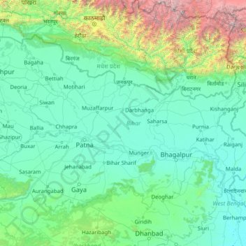
Name: Bihar topographic map, elevation, terrain.
Location: Bihar, India (24.28572 83.32126 27.52164 88.29823)
Average elevation: 606 m
Minimum elevation: 11 m
Maximum elevation: 8,419 m
Bihar covers a total area of 94,163 km2 (36,357 sq mi), with an average elevation above sea level of 173 feet (53 m). It is land locked by Nepal in the north, Jharkhand in the south West Bengal in the east and Uttar Pradesh to the west. It has three parts on the basis of physical and structural conditions: the Southern Plateau, the Shivalik Region, and Bihar's Gangetic Plain. Furthermore, the vast stretch of fertile Bihar Plain is divided by the Ganges River into two unequal parts – North Bihar and South Bihar. The Ganges flows west–east and, along with its tributaries, regularly floods parts of the Bihar plain. The main northern tributaries are the Gandak and Koshi, which originate in the Nepalese Himalayas, and the Bagmati, which originates in the Kathmandu Valley. Other tributaries are the Son, Budhi Gandak, Chandan, Orhani and Phalgu. Bihar has some small hills, such as the Rajgir hills in center, Kaimur Range in south-west and Shivalik Range in North. Bihar has notified forest area of 6,764.14 km2, which is 7.1 per cent of its geographical area. The sub-Himalayan foothills of Shivalik ranges, primary Someshwar and Dun mountain, in West Champaran district are clad in a belt of moist deciduous forest. As well as trees, this consists of scrub, grass and reeds.
Other topographic maps
Click on a map to view its topography, its elevation and its terrain.
Palay
India > Madhya Pradesh > Tonk Khurd Tahsil
Palay, Tonk Khurd Tahsil, Dewas District, Madhya Pradesh, India
Average elevation: 530 m
Nellikuppam
India > Tamil Nadu > Chengalpattu
Nellikuppam, Chengalpattu, Chengalpattu District, Tamil Nadu, 603108, India
Average elevation: 32 m
Mechuka
India > Arunachal Pradesh > Mechuka ADC
Mechuka, Mechuka ADC, Shi Yomi District, Arunachal Pradesh, India
Average elevation: 2,165 m
Tawang
India > Arunachal Pradesh > Tawang Circle
Tawang, Tawang Circle, Tawang District, Arunachal Pradesh, India
Average elevation: 3,280 m
Ankleshwar
India > Gujarat > Ankleshwar Taluka
Ankleshwar, Ankleshwar Taluka, Bharuch District, Gujarat, India
Average elevation: 17 m
Yashwant Nagar
India > Maharashtra > Umarga > Trikoli
Yashwant Nagar, Trikoli, Umarga, Dharashiv District, Maharashtra, India
Average elevation: 600 m
Dirang
India > Arunachal Pradesh > Dirang ADC
Dirang, Dirang ADC, West Kameng District, Arunachal Pradesh, India
Average elevation: 2,317 m
Bomdila
India > Arunachal Pradesh > Bomdila HQ
Bomdila, Bomdila HQ, West Kameng District, Arunachal Pradesh, India
Average elevation: 2,033 m
Krishnapur
India > Maharashtra > Chandurbazar
Krishnapur, Chandurbazar, Amravati District, Maharashtra, India
Average elevation: 348 m
Srinivasapuram
India > Telangana > Huzur nagar mandal
Srinivasapuram, Huzur nagar mandal, Suryapet District, Telangana, India
Average elevation: 104 m
Kodaikanal
Kodaikanal, Dindigul District, Tamil Nadu, India
Average elevation: 869 m
Arasikere
India > Karnataka > Arasikere taluku
Arasikere, Arasikere taluku, Hassan District, Karnataka, 573103, India
Average elevation: 835 m
Sangareddy
India > Telangana > Sangareddy mandal
Sangareddy, Sangareddy mandal, Sangareddy District, Telangana, 502001, India
Average elevation: 517 m
Majri
India > Punjab > Samana Tahsil
Majri, Samana Tahsil, Patiala District, Punjab, India
Average elevation: 244 m
Samana
India > Madhya Pradesh > Devendranagar Tahsil > Samana
Samana, Devendranagar Tahsil, Panna District, Madhya Pradesh, India
Average elevation: 326 m
Kawant
India > Gujarat > Kavant Taluka
Kawant, Kavant Taluka, Chhota Udaipur District, Gujarat, 391170, India
Average elevation: 200 m
Kishorganj
India > Madhya Pradesh > Rajnagar Tahsil > Bamitha
Kishorganj, Bamitha, Rajnagar Tahsil, Chhatarpur District, Madhya Pradesh, India
Average elevation: 245 m
Perumpetty
India > Kerala > Mallappally
Perumpetty, Mallappally, Pathanamthitta District, Kerala, India
Average elevation: 89 m
Kameswaram
India > Tamil Nadu > Kilvelur
Kameswaram, Kilvelur, Nagapattinam District, Tamil Nadu, 611110, India
Average elevation: 2 m
Bengaluru
India > Karnataka > Bangalore North
Bengaluru, Bangalore North, Bangalore Urban, Karnataka, India
Average elevation: 881 m
Puducherry
India > Puducherry > Puducherry Taluk
Puducherry, Puducherry Taluk, Puducherry District, Puducherry, 605001, India
Average elevation: 10 m
Badrinath
India > Uttarakhand > Joshimath Tehsil
Badrinath, Joshimath Tehsil, Chamoli District, Uttarakhand, India
Average elevation: 4,052 m
Faridpur
Faridpur, Bareilly District, Uttar Pradesh, India
Average elevation: 164 m
Dubli
India > Madhya Pradesh > Tarana Tahsil > Dubli
Dubli, Tarana Tahsil, Ujjain District, Madhya Pradesh, India
Average elevation: 494 m
Barmer
India > Rajasthan > Barmer Tehsil
Barmer, Barmer Tehsil, Barmer District, Rajasthan, 344001, India
Average elevation: 188 m
Mokila
India > Telangana > Shankarpalle mandal
Mokila, Shankarpalle mandal, Ranga Reddy District, Telangana, India
Average elevation: 569 m
Udaipur
Udaipur, Lahul and Spiti, Himachal Pradesh, India
Average elevation: 4,552 m
Koduvally
India > Kerala > Thamarassery
Koduvally, Thamarassery, Kozhikode district, Kerala, 673572, India
Average elevation: 41 m
Boys Company
India > Tamil Nadu > Coonoor
Boys Company, Coonoor, The Nilgiris District, Tamil Nadu, 643231, India
Average elevation: 1,881 m
Pykara
India > Tamil Nadu > Udhagamandalam
Pykara, Udhagamandalam, The Nilgiris District, Tamil Nadu, India
Average elevation: 2,104 m
Gudalur
Gudalur, The Nilgiris District, Tamil Nadu, India
Average elevation: 1,133 m