
Manipur topographic map
Interactive map
Click on the map to display elevation.
About this map
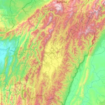
Name: Manipur topographic map, elevation, terrain.
Location: Manipur, India (23.83362 92.97071 25.69210 94.74524)
Average elevation: 810 m
Minimum elevation: 19 m
Maximum elevation: 2,997 m
The state lies at a latitude of 23°83'N – 25°68'N and a longitude of 93°03'E – 94°78'E. The total area covered by the state is 22,327 square kilometres (8,621 sq mi). The capital lies in an oval-shaped valley of approximately 700 square miles (2,000 km2), surrounded by blue mountains, at an elevation of 790 metres (2,590 ft) above sea level. The slope of the valley is from north to south. The mountain ranges create a moderated climate, preventing the cold winds from the north from reaching the valley and barring cyclonic storms.
Other topographic maps
Click on a map to view its topography, its elevation and its terrain.
Bengaluru
India > Karnataka > Bangalore North
Bengaluru, Bangalore North, Bengaluru Urban District, Karnataka, India
Average elevation: 881 m
Chennai
India > Tamil Nadu > Chennai
Chennai, Chennai District, Tamil Nadu, India
Average elevation: 8 m
Pune
India > Maharashtra > Pune City > Pune
Pune, Pune City, Pune District, Maharashtra, 411001, India
Average elevation: 641 m
3d
India > Rajasthan > Ganganagar Tehsil > 1 LNP
3d, 1 LNP, Ganganagar Tehsil, Sri Ganganagar District, Rajasthan, India
Average elevation: 178 m
Western Ghats
Western Ghats, Idukki, Kerala, 685614, India
Average elevation: 2,225 m
Coimbatore
India > Tamil Nadu > Coimbatore North
Coimbatore, Coimbatore North, Coimbatore District, Tamil Nadu, 641001, India
Average elevation: 452 m
Kolkata
Kolkata, Kolkata District, West Bengal, 700073, India
Average elevation: 5 m
Rampur
India > Odisha > Madanpur Rampur
Rampur, Madanpur Rampur, Kalahandi District, Odisha, 766112, India
Average elevation: 211 m
Mysuru
India > Karnataka > Mysuru taluk
Mysuru, Mysuru taluk, Mysuru District, Karnataka, 570001, India
Average elevation: 727 m
Periyar River
India > Kerala > Paravur > Edayar
Periyar River, Njaarakkaattu, Edayar, Paravur, Ernakulam District, Kerala, India
Average elevation: 8 m
Nanded
India > Maharashtra > Nanded
Nanded, Nanded District, Maharashtra, 431600, India
Average elevation: 376 m
Shimla
India > Himachal Pradesh > Shimla (urban)
Shimla, Shimla (urban), Shimla District, Himachal Pradesh, 171001, India
Average elevation: 1,557 m
Thiruvananthapuram
India > Kerala > Thiruvananthapuram
Thiruvananthapuram, Thiruvananthapuram District, Kerala, 695001, India
Average elevation: 33 m
Jagara
India > Karnataka > Chikkamagaluru taluku
Jagara, Chikkamagaluru taluku, Chikkamagaluru District, Karnataka, India
Average elevation: 824 m
Bachupally mandal
Bachupally mandal, Medchal–Malkajgiri District, Telangana, 500090, India
Average elevation: 593 m
Patna
India > Bihar > Patna Rural
Patna, Patna Rural, Patna District, Bihar, 800001, India
Average elevation: 51 m
Jaipur
India > Rajasthan > Jaipur Tehsil
Jaipur, Jaipur Municipal Corporation, Jaipur Tehsil, Jaipur District, Rajasthan, 302001, India
Average elevation: 408 m
Sarati
India > Maharashtra > Sakoli Taluka
Sarati, Sakoli Taluka, Bhandara District, Maharashtra, India
Average elevation: 253 m
Limpiya Pass
India > Uttarakhand > Dharchula Tehsil (India)
Limpiya Pass, Dharchula Tehsil (India), Pithoragarh District, Uttarakhand, India
Average elevation: 5,393 m
Gurjal
India > Telangana > Gandhari mandal
Gurjal, Gandhari mandal, Kamareddy District, Telangana, India
Average elevation: 543 m
Hosur
India > Tamil Nadu > Hosur
Hosur, Krishnagiri District, Tamil Nadu, 635109, India
Average elevation: 859 m
Kallooppara
India > Kerala > Mallappally
Kallooppara, Mallappally, Pathanamthitta District, Kerala, 689583, India
Average elevation: 19 m
Indore
India > Madhya Pradesh > Juni Indore Tahsil
Indore, Juni Indore Tahsil, Indore District, Madhya Pradesh, 452001, India
Average elevation: 555 m
Triprayar Beach
India > Kerala > Chavakkad > Thriprayar
Triprayar Beach, Thriprayar, Chavakkad, Thrissur District, Kerala, India
Average elevation: 4 m
Gangodanahalli
India > Karnataka > Bangalore North
Gangodanahalli, Bangalore North, Bengaluru Urban, Karnataka, 560018, India
Average elevation: 865 m