
Himachal Pradesh topographic map
Interactive map
Click on the map to display elevation.
About this map
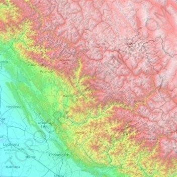
Name: Himachal Pradesh topographic map, elevation, terrain.
Location: Himachal Pradesh, India (30.37717 75.59401 33.25567 79.01238)
Average elevation: 2,869 m
Minimum elevation: 232 m
Maximum elevation: 6,687 m
Due to extreme variation in elevation, great variation occurs in the climatic conditions of Himachal. The climate varies from hot and humid subtropical in the southern tracts to, with more elevation, cold, alpine, and glacial in the northern and eastern mountain ranges. The state's winter capital, Dharamsala receives very heavy rainfall, while areas like Lahaul and Spiti are cold and almost rainless. Broadly, Himachal experiences three seasons: summer, winter, and rainy season. Summer lasts from mid-April till the end of June and most parts become very hot (except in the alpine zone which experiences a mild summer) with the average temperature ranging from 28 to 32 °C (82 to 90 °F). Winter lasts from late November till mid-March. Snowfall is common in alpine tracts. Pollution is affecting the climate of almost all the states of India. Due to steps taken by governments to prevent pollution, Himachal Pradesh has become the first smoke-free state in India which means cooking in the entire state is free of traditional chulhas.
Other topographic maps
Click on a map to view its topography, its elevation and its terrain.
Bengaluru
India > Karnataka > Bangalore North
Bengaluru, Bangalore North, Bengaluru Urban District, Karnataka, India
Average elevation: 881 m
Chennai
India > Tamil Nadu > Chennai
Chennai, Chennai District, Tamil Nadu, India
Average elevation: 8 m
Pune
India > Maharashtra > Pune City > Pune
Pune, Pune City, Pune District, Maharashtra, 411001, India
Average elevation: 641 m
3d
India > Rajasthan > Ganganagar Tehsil > 1 LNP
3d, 1 LNP, Ganganagar Tehsil, Sri Ganganagar District, Rajasthan, India
Average elevation: 178 m
Bachupally mandal
Bachupally mandal, Medchal–Malkajgiri District, Telangana, 500090, India
Average elevation: 593 m
Kolkata
Kolkata, Kolkata District, West Bengal, 700073, India
Average elevation: 5 m
Western Ghats
Western Ghats, Idukki, Kerala, 685614, India
Average elevation: 2,225 m
Prayagraj
India > Uttar Pradesh > Prayagraj
Prayagraj, Prayagraj District, Uttar Pradesh, 211001, India
Average elevation: 91 m
Coimbatore
India > Tamil Nadu > Coimbatore North
Coimbatore, Coimbatore North, Coimbatore District, Tamil Nadu, 641001, India
Average elevation: 452 m
Mysuru
India > Karnataka > Mysuru taluk
Mysuru, Mysuru taluk, Mysuru District, Karnataka, 570001, India
Average elevation: 727 m
Patna
India > Bihar > Patna Rural
Patna, Patna Rural, Patna District, Bihar, 800001, India
Average elevation: 51 m
Rampur
India > Odisha > Madanpur Rampur
Rampur, Madanpur Rampur, Kalahandi District, Odisha, 766112, India
Average elevation: 211 m
Phlangmawsyrpat
Phlangmawsyrpat, Mawsynram, East Khasi Hills District, Meghalaya, 793113, India
Average elevation: 748 m
Periyar River
India > Kerala > Paravur > Edayar
Periyar River, Njaarakkaattu, Edayar, Paravur, Ernakulam District, Kerala, India
Average elevation: 8 m
Nanded
India > Maharashtra > Nanded
Nanded, Nanded District, Maharashtra, 431600, India
Average elevation: 376 m
Shimla
India > Himachal Pradesh > Shimla (urban)
Shimla, Shimla (urban), Shimla District, Himachal Pradesh, 171001, India
Average elevation: 1,557 m
Kubeer mandal
Kubeer mandal, Nirmal District, Telangana, India
Average elevation: 417 m
Thiruvananthapuram
India > Kerala > Thiruvananthapuram
Thiruvananthapuram, Thiruvananthapuram District, Kerala, 695001, India
Average elevation: 33 m
Jagara
India > Karnataka > Chikkamagaluru taluku
Jagara, Chikkamagaluru taluku, Chikkamagaluru District, Karnataka, India
Average elevation: 824 m
Jaipur
India > Rajasthan > Jaipur Tehsil
Jaipur, Jaipur Municipal Corporation, Jaipur Tehsil, Jaipur District, Rajasthan, 302001, India
Average elevation: 408 m
Sarati
India > Maharashtra > Sakoli Taluka
Sarati, Sakoli Taluka, Bhandara District, Maharashtra, India
Average elevation: 253 m
Limpiya Pass
India > Uttarakhand > Dharchula Tehsil (India)
Limpiya Pass, Dharchula Tehsil (India), Pithoragarh District, Uttarakhand, India
Average elevation: 5,393 m
Gurjal
India > Telangana > Gandhari mandal
Gurjal, Gandhari mandal, Kamareddy District, Telangana, India
Average elevation: 543 m
Hosur
India > Tamil Nadu > Hosur
Hosur, Krishnagiri District, Tamil Nadu, 635109, India
Average elevation: 859 m