
Make a donation
Gear up for your next adventure:
As an Amazon Associate, this site earns from qualifying purchases at no extra cost to you.
Canazei topographic map
Click on the map to display elevation.
Make a donation
Gear up for your next adventure:
As an Amazon Associate, this site earns from qualifying purchases at no extra cost to you.
About this map
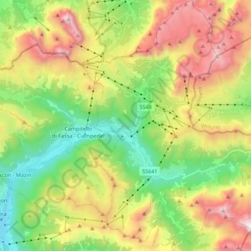
Name: Canazei topographic map, elevation, terrain.
Average elevation: 2,123 m
Minimum elevation: 1,314 m
Maximum elevation: 3,298 m
Make a donation
Gear up for your next adventure:
As an Amazon Associate, this site earns from qualifying purchases at no extra cost to you.
Other topographic maps
Click on a map to view its topography, its elevation and its terrain.
Castel Beseno
Italy > Trentino-Alto Adige/Südtirol > Provincia di Trento > Besenello > Sottocastello
Average elevation: 389 m
Cascata della Valletta Alta
Italy > Trentino-Alto Adige/Südtirol > Provincia di Trento
Average elevation: 2,298 m
Nanno
Italy > Trentino-Alto Adige/Südtirol > Provincia di Trento > Ville d'Anaunia
Average elevation: 534 m
Make a donation
Gear up for your next adventure:
As an Amazon Associate, this site earns from qualifying purchases at no extra cost to you.
Trento
Italy > Trentino-Alto Adige/Südtirol > Provincia di Trento > Trento
Trento has a humid subtropical-continental climate (Cfa-Dfa) through most of its populated areas according to the Köppen climate classification. Boroughs at higher elevation like Viote have a colder alpine climate (Dw). Monthly average temperatures range between 1.6 °C (January) and 23.4 °C (July). Annual…
Average elevation: 970 m
Val di Non
Italy > Trentino-Alto Adige/Südtirol > Provincia di Trento > Ville d'Anaunia
Average elevation: 989 m
Roncafort
Italy > Trentino-Alto Adige/Südtirol > Provincia di Trento > Trento
Average elevation: 341 m
Make a donation
Gear up for your next adventure:
As an Amazon Associate, this site earns from qualifying purchases at no extra cost to you.
Piani de Porcil
Italy > Trentino-Alto Adige/Südtirol > Provincia di Trento > Vallelaghi
Average elevation: 1,122 m
Passo Fedaia
Italy > Trentino-Alto Adige/Südtirol > Provincia di Trento > Canazei
Average elevation: 2,249 m
Fucine
Italy > Trentino-Alto Adige/Südtirol > Provincia di Trento > Ossana > Fucine
Average elevation: 1,328 m
Make a donation
Gear up for your next adventure:
As an Amazon Associate, this site earns from qualifying purchases at no extra cost to you.
Fontana
Italy > Trentino-Alto Adige/Südtirol > Provincia di Trento > Bresimo > Bresimo > Fontana
Average elevation: 1,390 m
Maroc
Italy > Trentino-Alto Adige/Südtirol > Provincia di Trento > Folgaria > Scandelli
Average elevation: 913 m
Make a donation
Gear up for your next adventure:
As an Amazon Associate, this site earns from qualifying purchases at no extra cost to you.
Riva del Garda
Italy > Trentino-Alto Adige/Südtirol > Provincia di Trento > Riva del Garda
Average elevation: 485 m
Jouf de Pordoi - Passo Pordoi - Pordoijoch
Italy > Trentino-Alto Adige/Südtirol > Provincia di Trento > Canazei
Average elevation: 2,283 m
Mezzolago
Italy > Trentino-Alto Adige/Südtirol > Provincia di Trento > Mezzolago
Average elevation: 886 m
Make a donation
Gear up for your next adventure:
As an Amazon Associate, this site earns from qualifying purchases at no extra cost to you.