
Make a donation
Gear up for your next adventure:
As an Amazon Associate, this site earns from qualifying purchases at no extra cost to you.
Belle Meade topographic map
Click on the map to display elevation.
Make a donation
Gear up for your next adventure:
As an Amazon Associate, this site earns from qualifying purchases at no extra cost to you.
About this map
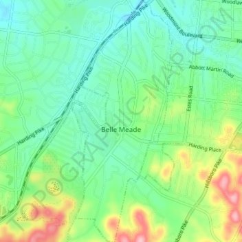
Name: Belle Meade topographic map, elevation, terrain.
Average elevation: 183 m
Minimum elevation: 136 m
Maximum elevation: 294 m
Make a donation
Gear up for your next adventure:
As an Amazon Associate, this site earns from qualifying purchases at no extra cost to you.
Other topographic maps
Click on a map to view its topography, its elevation and its terrain.
Make a donation
Gear up for your next adventure:
As an Amazon Associate, this site earns from qualifying purchases at no extra cost to you.
Lockeland Springs Park
United States > Tennessee > Davidson County > Nashville-Davidson
Average elevation: 149 m
Make a donation
Gear up for your next adventure:
As an Amazon Associate, this site earns from qualifying purchases at no extra cost to you.
Little Creek
United States > Tennessee > Davidson County > Nashville-Davidson
Average elevation: 194 m
Make a donation
Gear up for your next adventure:
As an Amazon Associate, this site earns from qualifying purchases at no extra cost to you.
Whites Creek
United States > Tennessee > Davidson County > Nashville-Davidson
Average elevation: 143 m
Make a donation
Gear up for your next adventure:
As an Amazon Associate, this site earns from qualifying purchases at no extra cost to you.
Bellshire
United States > Tennessee > Davidson County > Nashville > Bellshire
Average elevation: 186 m
Seventeen Seventysix Estates
United States > Tennessee > Davidson County > Nashville > Seventeen Seventysix Estates
Average elevation: 199 m
Antioch Park
United States > Tennessee > Davidson County > Nashville-Davidson > Antioch
Average elevation: 173 m
Make a donation
Gear up for your next adventure:
As an Amazon Associate, this site earns from qualifying purchases at no extra cost to you.
Hermitage Island
United States > Tennessee > Davidson County > Nashville-Davidson
Average elevation: 157 m
Town Park Estates
United States > Tennessee > Davidson County > Nashville-Davidson
Average elevation: 174 m
Cherry Hills
United States > Tennessee > Davidson County > Nashville-Davidson
Average elevation: 166 m
Make a donation
Gear up for your next adventure:
As an Amazon Associate, this site earns from qualifying purchases at no extra cost to you.
Colewood Acres
United States > Tennessee > Davidson County > Nashville-Davidson
Average elevation: 184 m
Whites Creek
United States > Tennessee > Davidson County > Nashville-Davidson
Average elevation: 180 m
Make a donation
Gear up for your next adventure:
As an Amazon Associate, this site earns from qualifying purchases at no extra cost to you.
Edge-O-Lake Estates
United States > Tennessee > Davidson County > Nashville-Davidson
Average elevation: 175 m
Harpeth River
United States > Tennessee > Davidson County > Nashville-Davidson
Average elevation: 197 m
Make a donation
Gear up for your next adventure:
As an Amazon Associate, this site earns from qualifying purchases at no extra cost to you.
Myrtlewood Estates
United States > Tennessee > Davidson County > Nashville-Davidson
Average elevation: 206 m
West Meade
United States > Tennessee > Davidson County > Nashville > West Meade
Average elevation: 167 m
Make a donation
Gear up for your next adventure:
As an Amazon Associate, this site earns from qualifying purchases at no extra cost to you.