
Make a donation
Gear up for your next adventure:
As an Amazon Associate, this site earns from qualifying purchases at no extra cost to you.
Pig Island topographic map
Click on the map to display elevation.
Make a donation
Gear up for your next adventure:
As an Amazon Associate, this site earns from qualifying purchases at no extra cost to you.
About this map
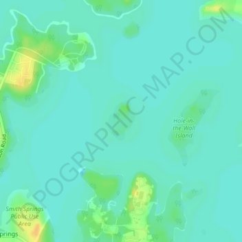
Name: Pig Island topographic map, elevation, terrain.
Average elevation: 152 m
Minimum elevation: 145 m
Maximum elevation: 173 m
Make a donation
Gear up for your next adventure:
As an Amazon Associate, this site earns from qualifying purchases at no extra cost to you.
Other topographic maps
Click on a map to view its topography, its elevation and its terrain.
Radnor Lake State Natural Area
United States > Tennessee > Davidson County > Nashville-Davidson
Average elevation: 265 m
Make a donation
Gear up for your next adventure:
As an Amazon Associate, this site earns from qualifying purchases at no extra cost to you.
Make a donation
Gear up for your next adventure:
As an Amazon Associate, this site earns from qualifying purchases at no extra cost to you.
Little Creek
United States > Tennessee > Davidson County > Nashville-Davidson
Average elevation: 194 m
Make a donation
Gear up for your next adventure:
As an Amazon Associate, this site earns from qualifying purchases at no extra cost to you.
Town Park Estates
United States > Tennessee > Davidson County > Nashville-Davidson
Average elevation: 174 m
Cherry Hills
United States > Tennessee > Davidson County > Nashville-Davidson
Average elevation: 166 m
Make a donation
Gear up for your next adventure:
As an Amazon Associate, this site earns from qualifying purchases at no extra cost to you.
Colewood Acres
United States > Tennessee > Davidson County > Nashville-Davidson
Average elevation: 184 m
Whites Creek
United States > Tennessee > Davidson County > Nashville-Davidson
Average elevation: 180 m
Edge-O-Lake Estates
United States > Tennessee > Davidson County > Nashville-Davidson
Average elevation: 175 m
Make a donation
Gear up for your next adventure:
As an Amazon Associate, this site earns from qualifying purchases at no extra cost to you.
Myrtlewood Estates
United States > Tennessee > Davidson County > Nashville-Davidson
Average elevation: 206 m
Make a donation
Gear up for your next adventure:
As an Amazon Associate, this site earns from qualifying purchases at no extra cost to you.
Lake Wautaga
United States > Tennessee > Davidson County > Nashville-Davidson
Average elevation: 168 m