
Gangjin-gun topographic map
Interactive map
Click on the map to display elevation.
About this map
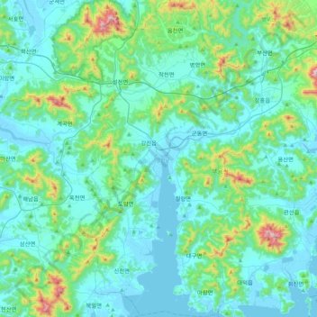
Name: Gangjin-gun topographic map, elevation, terrain.
Location: Gangjin-gun, South Jeolla, South Korea (34.44387 126.65764 34.78646 126.88604)
Average elevation: 112 m
Minimum elevation: -2 m
Maximum elevation: 752 m
Other topographic maps
Click on a map to view its topography, its elevation and its terrain.
Doil-dong
South Korea > Pyeongtaek-si > Doil-dong
Doil-dong, Pyeongtaek-si, 17738, South Korea
Average elevation: 59 m
Jeju-si
South Korea > Jeju-do > Jeju-si
Jeju-si, Jeju, Jeju-do, 63183, South Korea
Average elevation: 263 m
Gyeonggi
South Korea > Gyeonggi-do > Suwon-si > Gyo-dong
Gyeonggi, Paldalsan-ro, Gyo-dong, Paldal-gu, Suwon-si, Gyeonggi-do, 16251, South Korea
Average elevation: 53 m
Seoul
South Korea > Seoul > Seodaemun-gu
Sinchon-dong, Seodaemun-gu, Seoul, South Korea
Average elevation: 66 m
863
South Korea > North Gyeongsang > Yeongju-si
863, Yeongju-si, North Gyeongsang, South Korea
Average elevation: 746 m
Jung-dong
South Korea > Gyeonggi-do > Yongin-si > Giheung-gu > Jung-dong
Jung-dong, Giheung-gu, Yongin-si, Gyeonggi-do, 17009, South Korea
Average elevation: 162 m
Jangjeon-dong
South Korea > Busan > Jangjeon-dong
Jangjeon-dong, Geumjeong-gu, Busan, South Korea
Average elevation: 122 m