
Seoul topographic map
Interactive map
Click on the map to display elevation.
About this map
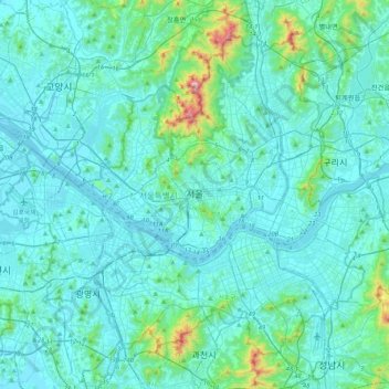
Name: Seoul topographic map, elevation, terrain.
Location: Seoul, South Korea (37.42854 126.76443 37.70148 127.18377)
Average elevation: 80 m
Minimum elevation: 1 m
Maximum elevation: 810 m
Other topographic maps
Click on a map to view its topography, its elevation and its terrain.
Turczaninow Hornbeam Tree at Chamseongdan Altar
South Korea > Ganghwa-gun > Incheon > Hwado-myeon
Average elevation: 155 m
Hallasan
The occurrence of the highest temperature coincides with the formation position of Eddy, and when the wind is weak, it is formed in the middle mountain region. When the wind is weak, the warmth is accumulated in the middle layer, so the maximum temperature in the mid-mountainous area is higher than the maximum…
Average elevation: 1,652 m
Changdeokgung Palace
South Korea > Jongno 1·2·3·4(ilisamsa)-ga-dong
Changdeokgung was the most favored palace of many Joseon princes and retained many elements dating from the Three Kingdoms of Korea period that were not incorporated in the more contemporary Gyeongbokgung. One such element is the fact that the buildings of Changdeokgung blend with the natural topography of the…
Average elevation: 65 m