Geolocate

County Mayo topographic map

Interactive map

Click on the map to display elevation.

About this map

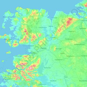
Name: County Mayo topographic map, elevation, terrain.

Location: County Mayo, Connacht, Ireland (53.47191 -10.32256 54.34542 -8.58283)

Average elevation: 66 m

Minimum elevation: -2 m

Maximum elevation: 766 m

Other topographic maps

Click on a map to view its topography, its elevation and its terrain.

Dublin

Ireland > County Dublin

Dublin, County Dublin, Leinster, Ireland

Average elevation: 42 m

Cork

Ireland > County Cork > Cork

Cork, County Cork, Munster, T12 T997, Ireland

Average elevation: 94 m

Corduff (Kelly)

Ireland > County Monaghan

Corduff (Kelly), Enagh ED, Carrickmacross-Castleblaney Municipal District, County Monaghan, Ulster, Ireland

Average elevation: 50 m

Oldcastle

Ireland > County Meath

Oldcastle, Oldcastle ED, The Municipal District of Kells, County Meath, Leinster, Ireland

Average elevation: 102 m

Paulstown

Ireland > County Kilkenny

Paulstown, The Municipal District of Castlecomer, County Kilkenny, Leinster, Ireland

Average elevation: 59 m

Newtown

Ireland > County Laois

Newtown, Doonane ED, The Municipal District of Graiguecullen — Portarlington, County Laois, Leinster, R14 N521, Ireland

Average elevation: 187 m

Galway City

Ireland > Galway City

Galway, Galway City, County Galway, Connacht, H91 YD86, Ireland

Average elevation: 26 m

County Kerry

Ireland

County Kerry, Munster, Ireland

Average elevation: 123 m

Ballinvally

Ireland > County Kilkenny

Ballinvally, Shankill, The Municipal District of Castlecomer, County Kilkenny, Leinster, Ireland

Average elevation: 138 m

Ballylynan

Ireland > County Laois

Ballylynan, The Municipal District of Graiguecullen — Portarlington, County Laois, Leinster, R14 E171, Ireland

Average elevation: 82 m

Rosslare Harbour

Ireland > County Wexford

Rosslare Harbour, County Wexford, Leinster, Y35 XWV6, Ireland

Average elevation: 7 m

Bunlick

Ireland > County Cork

Bunlick, Skibbereen Rural, West Cork, County Cork, Munster, Ireland

Average elevation: 32 m

County Limerick

Ireland

County Limerick, Munster, Ireland

Average elevation: 107 m

County Donegal

Ireland

County Donegal, Ulster, Ireland

Average elevation: 74 m

County Cork

Ireland

County Cork, Munster, Ireland

Average elevation: 78 m

Sligo

Ireland > County Sligo

Sligo, Sligo Municipal Borough District, County Sligo, Connacht, Ireland

Average elevation: 21 m

Rivers

Ireland > County Limerick > Limerick

Rivers, Vision Care, Ballyvarra ED, The Metropolitan District of Limerick City, Limerick, County Limerick, Munster, Ireland

Average elevation: 19 m

County Galway

Ireland

County Galway, Connacht, Ireland

Average elevation: 68 m

County Wexford

Ireland

County Wexford, Leinster, Ireland

Average elevation: 63 m

County Clare

Ireland

County Clare, Munster, Ireland

Average elevation: 67 m

Kilcumber

Ireland > County Offaly

Kilcumber, Edenderry Rural ED, The Municipal District of Edenderry, County Offaly, Leinster, Ireland

Average elevation: 70 m

Kyletalesha

Ireland > County Laois

Kyletalesha, Borris ED, The Municipal District of Portlaoise, County Laois, Leinster, Ireland

Average elevation: 82 m

Killadangan

Ireland > County Tipperary

Killadangan, Knigh, The Municipal District of Nenagh, County Tipperary, Munster, Ireland

Average elevation: 51 m

Cobh

Ireland > County Cork

Cobh, County Cork, Munster, Ireland

Average elevation: 26 m

County Wicklow

Ireland

County Wicklow, Leinster, Ireland

Average elevation: 166 m

Ardgroom

Ireland > County Cork

Ardgroom, West Cork, County Cork, Munster, Ireland

Average elevation: 56 m

County Waterford

Ireland > County Waterford

County Waterford, Munster, Ireland

Average elevation: 86 m

Cork

Ireland > County Cork

Cork, County Cork, Munster, Ireland

Average elevation: 79 m

Cloon

Ireland > County Kerry

Cloon, Emlagh ED, Kenmare Municipal District, County Kerry, Munster, Ireland

Average elevation: 25 m

Millstreet

Ireland > County Cork

Millstreet, Municipal District of Macroom, County Cork, Munster, Ireland

Average elevation: 140 m

Ballina

Ireland > County Mayo

Ballina, Ballina Municipal District, County Mayo, Connacht, Ireland

Average elevation: 19 m

Portlaoise

Ireland > County Laois

Portlaoise, The Municipal District of Portlaoise, County Laois, Leinster, Ireland

Average elevation: 101 m

Lissardagh

Ireland > County Cork

Lissardagh, Warrenscourt, Municipal District of Macroom, County Cork, Munster, Ireland

Average elevation: 109 m

Glenballythomas

Ireland > County Roscommon

Glenballythomas, Ogulla ED, Boyle Municipal District, County Roscommon, Connacht, Ireland

Average elevation: 124 m

Greenfield

Ireland > County Kildare

Greenfield, Kingsbry, Maynooth ED, The Municipal District of Clane — Maynooth, County Kildare, Leinster, Ireland

Average elevation: 63 m

Malahide (Union) 1900

Ireland > County Dublin > Malahide

Malahide (Union) 1900, Malahide, Fingal, County Dublin, Leinster, Ireland

Average elevation: 12 m

Coon

Ireland > County Kilkenny

Coon, The Municipal District of Castlecomer, County Kilkenny, Leinster, Ireland

Average elevation: 221 m

Clew Bay

Ireland > County Mayo

Clew Bay, County Mayo, Connacht, Ireland

Average elevation: 56 m

County Meath

Ireland

County Meath, Leinster, Ireland

Average elevation: 64 m

Addergoole

Ireland > County Mayo

Addergoole, County Mayo, Connacht, F28 C827, Ireland

Average elevation: 88 m

Blackwater

Ireland > County Wexford

Blackwater, The Municipal District of Gorey — Kilmuckridge, County Wexford, Leinster, Y21 C576, Ireland

Average elevation: 37 m

Ardnahinch

Ireland > County Cork

Ardnahinch, Ballycottin ED, The Municipal District of East Cork, County Cork, Munster, Ireland

Average elevation: 5 m

Shanagarry

Ireland > County Cork

Shanagarry, The Municipal District of East Cork, County Cork, Munster, P25 HX82, Ireland

Average elevation: 14 m

Lawlor's Strand

Ireland > Dunmore East

Lawlor's Strand, Dunmore East, Ireland

Average elevation: 33 m

Meelin

Ireland > County Cork

Meelin, The Municipal District of Kanturk-Mallow, County Cork, Munster, Ireland

Average elevation: 246 m

Carrigataha

Ireland > County Tipperary

Carrigataha, Tubbrid, The Municipal District of Cahir — Cashel, County Tipperary, Munster, Ireland

Average elevation: 52 m

Bandon

Ireland > County Cork

Bandon, The Municipal District of Bandon-Kinsale, County Cork, Munster, Ireland

Average elevation: 59 m

Cloughjordan

Ireland > County Tipperary

Cloughjordan, Cloghjordan, The Municipal District of Nenagh, County Tipperary, Munster, E53 FD42, Ireland

Average elevation: 97 m

Caherlistrane

Ireland > County Galway

Caherlistrane, Kilcoona ED, Tuam Municipal District, County Galway, Connacht, Ireland

Average elevation: 37 m

Celbridge

Ireland > County Kildare

Celbridge, The Municipal District of Celbridge — Leixlip, County Kildare, Leinster, Ireland

Average elevation: 61 m