
County Cork topographic map
Interactive map
Click on the map to display elevation.
County Cork
County Cork is located in the province of Munster, bordering Kerry to the west, Limerick to the north, Tipperary to the north-east and Waterford to the east. The county shares separate mountainous borders with Tipperary and Kerry. The terrain on the Kerry border was formed between 360 and 374 million years ago, as part of the rising of the MacGillycuddy's Reeks and Caha Mountains mountains ranges. This occurred during the Devonian period when Ireland was part of a larger continental landmass and located south of the equator. The region's topography of peaks and valleys are characterised by steep ridges formed during the Hercynian period of folding and mountain formation some 300 million years ago.
About this map
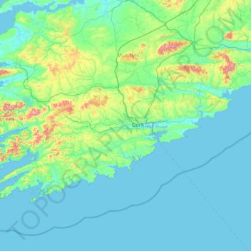
Name: County Cork topographic map, elevation, terrain.
Location: County Cork, Munster, Ireland (51.38887 -10.30252 52.38779 -7.84107)
Average elevation: 78 m
Minimum elevation: -2 m
Maximum elevation: 990 m
Ireland trails, hiking, mountain biking, running and outdoor activities
Other topographic maps
Click on a map to view its topography, its elevation and its terrain.
Easky
In Samuel Lewis's 1837 publication of A Topographical Dictionary of Ireland, Easky was described as having 6,124 inhabitants, of which 289 were in the village. Lewis noted that the village (made up of one long street) had petty sessions every fortnight and that Wednesday was market day. As well as other more…
Average elevation: 17 m
Blanchardstown
Blanchardstown was a predominantly rural area, with a small village, in western County Dublin, alongside the neighbouring district of Castleknock. Both areas shared a common history until well into the 19th century, when their development diverged. In A Topographical Dictionary of Ireland, published in 1837,…
Average elevation: 61 m