Geolocate

County Limerick topographic map

Click on the map to display elevation.

County Limerick

One possible meaning for the county's name in Irish Luimneach is "the flat area"; this description is accurate as the land consists mostly of a fertile limestone plain. Moreover, the county is ringed by mountains: the Slieve Felims to the northeast, the Galtees to the southeast, the Ballyhoura Mountains to the south, and the Mullaghareirk Mountains to the southwest and west. The highest point in the county is located in its southeast corner at Galtymore (919 m), which separates Limerick from County Tipperary. Limerick shares the 3rd-highest county peak in Ireland with Tipperary. The county is not simply a plain, its topography consists of hills and ridges. The eastern part of the county is part of the Golden Vale, which is well known for dairy produce and consists of rolling low hills. This gives way to very flat land around the centre of the county, with the exception being Knockfierna at 288 m high. Towards the west, the Mullaghareirk Mountains (Mullach an Radhairc in Irish, roughly meaning "mountains of the view") push across the county offering extensive views east over the county and west into County Kerry.

Wikipedia (CC-BY-SA 3.0)

About this map

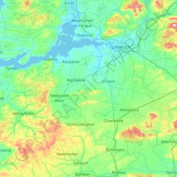
Name: County Limerick topographic map, elevation, terrain.

Location: County Limerick, Munster, Ireland (52.28020 -9.36543 52.69629 -8.15637)

Average elevation: 107 m

Minimum elevation: -2 m

Maximum elevation: 688 m

Ireland trails, hiking, mountain biking, running and outdoor activities

Other topographic maps

Click on a map to view its topography, its elevation and its terrain.

Cork

Ireland > County Cork > Cork

Average elevation: 94 m

Dundrum

Ireland > County Dublin

Average elevation: 79 m

Galway City

Ireland > Galway City

Average elevation: 26 m

Rosscahill

Ireland > County Galway

Average elevation: 36 m

Dundrum

Ireland > County Dublin

Average elevation: 79 m

Scartaglen

Ireland > County Kerry

Average elevation: 133 m

Maghera Strand

Ireland

Average elevation: 37 m

Inis Meáin

Ireland > County Donegal

Average elevation: 1 m

Mungret

Ireland > County Limerick > Limerick

Average elevation: 10 m

Cromane

Ireland

Average elevation: 3 m

Cashlaundrumlahan

Ireland > County Galway

Average elevation: 310 m

Mount Brandon

Ireland > County Kerry

Average elevation: 572 m

Doolin Cave

Ireland > County Clare

Average elevation: 87 m

Watergrasshill

Ireland > County Cork

According to A Topographical Dictionary of Ireland, published by Samuel Lewis in 1837, Watergrasshill then had a population of 533 people.

Average elevation: 164 m

Tallaght

Ireland > County Dublin

Average elevation: 121 m

Rathcroghan Mound

Ireland > County Roscommon

Average elevation: 127 m

Bridgetown

Ireland > County Clare

Average elevation: 68 m

Newtown Hill

Ireland > County Dublin

Average elevation: 95 m

Annayalla

Ireland > County Monaghan

Average elevation: 123 m

Hugginstown

Ireland > County Kilkenny

Average elevation: 129 m

Clare

Ireland > County Galway

Average elevation: 30 m

Farranfore

Ireland > County Kerry

Average elevation: 59 m

Ward Cross

Ireland > County Dublin

Average elevation: 75 m

Corlismore

Ireland > County Cavan

Average elevation: 73 m

Poolbeg Lighthouse

Ireland > County Dublin > Dublin

Average elevation: 0 m

Stonyford

Ireland > County Kilkenny

Average elevation: 64 m

Beaumont Park

Ireland > County Cork > Cork

Average elevation: 12 m

Knockmore

Ireland > County Mayo

Average elevation: 108 m

Killiney Hill

Ireland > County Dublin > Killiney

Average elevation: 40 m

Knockaderry

Ireland > County Waterford > Coolnasmear

Average elevation: 147 m

Geevagh

Ireland > County Sligo

Average elevation: 92 m

Blacklion

Ireland > County Cavan

Average elevation: 92 m

Yellow

Ireland > County Kerry

Average elevation: 209 m

Harbour

Ireland > County Offaly

Average elevation: 62 m

Ballinagh

Ireland > County Cavan > Bellananagh

Average elevation: 94 m

Blackrock

Ireland > County Dublin

Average elevation: 30 m

Ardclough

Ireland > County Kildare

Average elevation: 76 m

Bannow Bay

Ireland

Average elevation: 11 m

Moneystown

Ireland > County Wicklow

Average elevation: 223 m

Bohermeen

Ireland > County Meath

Average elevation: 74 m

Drimoleague

Ireland > County Cork

Average elevation: 89 m

Nohoval

Ireland > County Cork

Average elevation: 56 m

Blanchardstown

Ireland > County Dublin

Blanchardstown was a predominantly rural area, with a small village, in western County Dublin, alongside the neighbouring district of Castleknock. Both areas shared a common history until well into the 19th century, when their development diverged. In A Topographical Dictionary of Ireland, published in 1837,…

Average elevation: 61 m

Ballybrown

Ireland > County Limerick > Limerick

Average elevation: 9 m

Sneem

Ireland > County Kerry > Scrahanagaur

Average elevation: 27 m

Knockavilla

Ireland > County Cork

Average elevation: 85 m

Slieve League

Ireland > County Donegal

Average elevation: 233 m

Blackrock

Ireland > County Louth

Average elevation: 5 m

Longford

Ireland > County Longford

Average elevation: 57 m

Lough Nagreany

Ireland > County Donegal > Letterkenny

Average elevation: 36 m

Cornaseer

Ireland > County Cavan

Average elevation: 113 m

Glengarriff

Ireland > County Cork

Average elevation: 66 m

Knockanore

Ireland > County Kerry

Average elevation: 155 m

Galtymore

Ireland > County Limerick > The Municipal District of Cappamore — Kilmallock

Galtymore or Galteemore (Irish: Cnoc Mór na nGaibhlte, meaning 'big hill of the Galtees') is a mountain in the province of Munster, Ireland. At 917.9 metres (3,011 ft 6 in), it is one of Ireland's highest mountains, being the 12th-highest on the Arderin list, and 14th-highest on the Vandeleur-Lynam list.…

Average elevation: 594 m

Grangemockler

Ireland > County Tipperary

Average elevation: 165 m

Kinvarra

Ireland > County Galway

Average elevation: 11 m

Wild Nephin Wilderness

Ireland > County Mayo

Average elevation: 117 m

John's River

Ireland > County Waterford

Average elevation: 23 m

Waterfall

Ireland > County Cork

Average elevation: 83 m

Abbey Island

Ireland > County Kerry

Average elevation: 12 m

Castledermot

Ireland > County Kildare

Average elevation: 83 m

Moylussa

Ireland > County Clare

Average elevation: 372 m

Newtown Forbes

Ireland > County Longford

Average elevation: 56 m

Stradone

Ireland > County Cavan

Average elevation: 117 m

Ticknevin

Ireland > County Kildare

Average elevation: 80 m

Magheracloone

Ireland > County Monaghan

Average elevation: 57 m

Bawnboy

Ireland > County Cavan

Average elevation: 63 m

Ahane

Ireland > County Limerick > Limerick

Average elevation: 31 m

Tydavnet

Ireland > County Monaghan

Average elevation: 88 m

Wine Coos

Ireland

Average elevation: 32 m

Annacarty

Ireland > County Tipperary

Average elevation: 130 m

Bantry

Ireland > County Cork

Average elevation: 67 m

Ballinahown

Ireland > County Westmeath

Average elevation: 49 m

Leades Cross

Ireland > County Cork

Average elevation: 218 m

Brandon Hill

Ireland > County Kilkenny

Brandon Hill (Irish: Cnoc Bhréanail) is the highest mountain in County Kilkenny, Ireland, with an elevation of 515 m (1,690 ft) and prominence at 448 m (1,470 ft). The South Leinster Way, a long-distance trail, meandering through the Barrow Valley and traverses Brandon Hill. The village of Graiguenamanagh and…

Average elevation: 294 m

Dún Laoghaire

Ireland > County Dublin

Average elevation: 21 m

New Twopothouse

Ireland > County Cork

Average elevation: 114 m

Clare

Ireland > County Galway

Average elevation: 14 m

Kilpedder

Ireland > County Wicklow

Average elevation: 99 m

Allow

Ireland > County Cork

Average elevation: 119 m

River Brosna

Ireland > County Westmeath > Mullingar

Average elevation: 100 m

Sandyford

Ireland > County Dublin

Average elevation: 121 m

Curraghmore

Ireland > County Kerry

Average elevation: 528 m

Ballymount

Ireland > County Dublin > Clondalkin

Average elevation: 68 m

Cliffs of Moher

Ireland > County Clare

Average elevation: 55 m

Abbeyshrule

Ireland > County Longford

Average elevation: 66 m

Geevagh

Ireland > County Sligo

Average elevation: 92 m

Malin Head

Ireland > County Donegal

Average elevation: 4 m

Coragh Lough

Ireland > County Cavan

Average elevation: 98 m

Donabate Beach

Ireland > County Dublin

Average elevation: 2 m

Gear up for your next adventure:

📦Outdoor Storage Bags - Keep gear organized and dry
🌂Windproof Trekking Umbrellas - Protection during vertical Irish rain
🧗Climbing Gear - Essential equipment for climbing routes
🎁Outdoor Gift Ideas - Great gifts for adventurers
🔦UV Flashlights - Search for minerals or inspect maps at night

As an Amazon Associate, this site earns from qualifying purchases at no extra cost to you.