Geolocate

Sweden topographic map

Click on the map to display elevation.

Sweden

Sweden's topography is a diverse tapestry shaped by ancient geological processes and glacial activity. In the west, the Scandinavian Mountains form a natural border with Norway, featuring peaks like Kebnekaise, the country's highest point at approximately 2,097 meters. Moving eastward, the terrain transitions into vast forests and rolling hills, interspersed with numerous lakes—Sweden boasts around 95,700 lakes, including Vänern and Vättern, two of Europe's largest. The central region, known as the Central Swedish lowland, is characterized by fertile plains that support agriculture, while the southernmost area, particularly Skåne, features flat, arable lands reminiscent of neighboring Denmark. Along the eastern coastline, the landscape is dotted with archipelagos, comprising thousands of islands and islets, adding to the country's intricate coastal geography. This varied terrain not only defines Sweden's natural beauty but also influences its climate, biodiversity, and human settlement patterns.

About this map

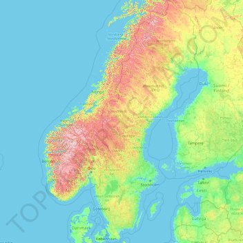
Name: Sweden topographic map, elevation, terrain.

Location: Sweden (55.13710 10.59350 69.05997 24.17768)

Average elevation: 163 m

Minimum elevation: -3 m

Maximum elevation: 2,107 m

Other topographic maps

Click on a map to view its topography, its elevation and its terrain.

Tbilisi

Georgia > Tbilisi

Most of the raions are named after historic quarters of the city. The citizens of Tbilisi widely recognise an informal system of smaller historic neighbourhoods. Such neighbourhoods are several, however, constituting a kind of hierarchy, because most of them have lost their distinctive topographic limits. The…

Average elevation: 713 m

Cork

Ireland > County Cork > Cork

Average elevation: 94 m

Rugombe Kasozi

Uganda > Kyenjojo

Average elevation: 1,512 m

Tallinn

Estonia > Tallinn

Average elevation: 22 m

Dubrovnik

Croatia > Dubrovnik

Average elevation: 91 m

Naas

Ireland > Naas

Average elevation: 102 m

Limerick

Ireland > Limerick

Limerick's climate is classified as temperate oceanic (Köppen Cfb). Met Éireann maintains a climatological weather station at Shannon Airport, 20 kilometres west of the city in County Clare. Shannon Airport records an average of 977 millimetres of precipitation annually, most of which is rain. Limerick has a…

Average elevation: 54 m

Glasgow

United Kingdom > Scotland > Glasgow City

Glasgow itself was reputed to have been founded by the Christian missionary Saint Mungo in the 6th century. He established a church on the Molendinar Burn, where the present Glasgow Cathedral stands, and in the following years Glasgow became a religious centre. Glasgow grew over the following centuries as part…

Average elevation: 128 m

Dollymount

Ireland

Average elevation: 6 m

Galway Bay

Ireland

Average elevation: 0 m

Clifden Bay

Ireland

Average elevation: 41 m

Lambs Head Bay

Ireland

Average elevation: 14 m

Doonbeg Head

Ireland

Average elevation: 32 m

Mace Head

Ireland

Average elevation: 3 m

Portacloy Bay

Ireland

Average elevation: 57 m

Dawros Bay

Ireland

Average elevation: 6 m

Crohy Head Sea Arch

Ireland

Average elevation: 28 m

Glendoo Mountain

Ireland

Average elevation: 480 m

Mine Head

Ireland

Average elevation: 22 m

Knockadoon Head

Ireland

Average elevation: 6 m

Frower Point

Ireland

Average elevation: 20 m

Downeen Point

Ireland

Average elevation: 11 m

Galley Head

Ireland

Average elevation: 3 m

Bolus Head

Ireland

Average elevation: 28 m

Doulus Head

Ireland

Average elevation: 16 m

Dunlicky Point

Ireland

Average elevation: 18 m

Kilkee Cliffs

Ireland

Average elevation: 19 m

Myles Big Stone

Ireland

Average elevation: 89 m

Tibberaghny Castle

Ireland

Average elevation: 18 m

Skeaghvasteen

Ireland

Average elevation: 97 m

Gaulstown Castle

Ireland

Average elevation: 181 m

Spinans Hill

Ireland

Average elevation: 244 m

Great Skellig

Ireland

Average elevation: 1 m

Dowth

Ireland

Average elevation: 32 m

Tory Hill

Ireland

Average elevation: 131 m

Trout Lake

Ireland

Average elevation: 81 m

Furry Glen

Ireland

Average elevation: 44 m

Ballyedmond

Ireland

Average elevation: 73 m

Ballycurry

Ireland

Average elevation: 178 m

Knockdrin

Ireland

Average elevation: 96 m

Maghera Strand

Ireland

Average elevation: 37 m

Cromane

Ireland

Average elevation: 3 m

River Shannon

Ireland

Average elevation: 39 m

Harare

Zimbabwe > Harare > Harare

Harare (/həˈrɑːreɪ/; formerly Salisbury /ˈsɔːlzbəri/) is the capital and most populous city of Zimbabwe. The city proper has an area of 940 km2 (371 mi2) and a population of 2.12 million in the 2012 census and an estimated 3.12 million in its metropolitan area in 2019. Situated in north-eastern…

Average elevation: 1,470 m

Buzinda

Uganda > Kabarole

Average elevation: 1,548 m

Bray Head

Ireland > County Wicklow

Average elevation: 44 m

Bray

Ireland > County Wicklow > Bray

Average elevation: 58 m

Kildare

Ireland > Kildare

Average elevation: 102 m

Tawangmangu

Indonesia > Central Java > Karanganyar

Average elevation: 1,015 m

Clondalkin

Ireland > County Dublin

Average elevation: 69 m

Doncaster

United Kingdom > England > Doncaster > Doncaster

Doncaster has a maritime climate lacking extreme temperatures, like much of the British Isles. Its low elevation in the Don Valley, in the lee of the Pennines, and inland from the North Sea, mean daytime summer temperatures are no lower than parts of South East England, despite the more northerly location. The…

Average elevation: 18 m

Bandung

Indonesia > West Java > Bandung

Bandung, the capital of West Java province, located about 180 kilometres (110 mi) southeast of Jakarta, is the third-largest city in Indonesia. Its elevation is 768 metres (2,520 ft) above sea level and is surrounded by up to 2,400 metres (7,900 feet) high Late Tertiary and Quaternary volcanic terrain. The 400…

Average elevation: 879 m

Kingscourt

Ireland > Kingscourt

Average elevation: 104 m

Mullingar

Ireland > County Westmeath

Average elevation: 101 m

Dalkey

Ireland > County Dublin

Average elevation: 22 m

Glenview

Ireland > County Cork

Average elevation: 97 m

Doo Lough

Ireland > County Kerry

Average elevation: 20 m

Knockmore

Ireland > County Mayo

Average elevation: 108 m

Ardclough

Ireland > County Kildare

Average elevation: 76 m

Sneem

Ireland > County Kerry > Scrahanagaur

Average elevation: 27 m

Sandyford

Ireland > County Dublin

Average elevation: 121 m

Keeper Hill

Ireland > County Tipperary

Average elevation: 431 m

Glenmalure

Ireland > County Wicklow

Average elevation: 295 m

Clarecastle

Ireland > County Clare

Average elevation: 7 m

Kilbride

Ireland > County Meath

Average elevation: 75 m

Drumshanbo

Ireland > County Leitrim

Average elevation: 66 m

Lanesborough

Ireland > County Longford

Average elevation: 41 m

Kilchreest

Ireland > County Galway

Average elevation: 75 m

Lugduff

Ireland > County Wicklow

Average elevation: 458 m

Montpelier Hill

Ireland > County Dublin

Average elevation: 274 m

Millstreet

Ireland > County Waterford

Average elevation: 112 m

Dunquin

Ireland > County Kerry > Dunquin

Average elevation: 132 m

Creggs

Ireland > County Galway

Average elevation: 75 m

Greenore Point

Ireland > County Wexford

Average elevation: 3 m

Scartaglen

Ireland > County Kerry

Average elevation: 135 m

Dartmouth Square

Ireland > Dublin

Average elevation: 18 m

Shanbally

Ireland > Shanbally

Average elevation: 34 m

Thailand

Thailand

Average elevation: 235 m

Benbulbin

Ireland > County Sligo

Average elevation: 257 m

Rathfarnham

Ireland > County Dublin

Average elevation: 56 m

Tulla

Ireland > County Clare

Average elevation: 49 m

Conna

Ireland > County Cork

Average elevation: 53 m

Slievenamon

Ireland > County Tipperary

Average elevation: 493 m

Glencullen

Ireland > County Dublin

Average elevation: 285 m

Shanagarry

Ireland > County Cork

Average elevation: 14 m

Kilnaleck

Ireland > County Cavan

Average elevation: 114 m

Lettermore

Ireland > County Galway

Average elevation: 8 m

Galway City

Ireland > Galway City

Average elevation: 26 m

Athlone

Ireland > County Westmeath > Athlone

Average elevation: 44 m

Drogheda

Ireland > County Louth > Drogheda

Average elevation: 38 m

Kaliwiro

Indonesia > Central Java > Wonosobo

Average elevation: 482 m

Bhagwanpur Jaisingh

India > Uttarakhand > Haldwani > Haldwani

Average elevation: 414 m

Carbury

Ireland > County Kildare

Average elevation: 90 m

Crossabeg

Ireland > County Wexford

Average elevation: 42 m

Cratloe

Ireland > County Clare

Average elevation: 44 m

Dowra

Ireland > County Cavan > Dowra

Average elevation: 67 m

Ravensdale

Ireland > County Louth

Average elevation: 124 m

Ballyconneely

Ireland > County Galway

Average elevation: 8 m

Wallstown Castle

Ireland > County Cork

Average elevation: 73 m

Gear up for your next adventure:

🎒Waterproof Backpacks - Protect your gear from rain on Irish hikes
Camping Tents - Top tents for Irish weather and conditions
🧣Multi-functional Neckwear - Protect against wind and sun with versatile Buffs
🔋Solar Power Banks - Keep your GPS and phone charged in the Irish wilderness
🛰️Handheld GPS Units - Professional satellite navigation for Irish highlands

As an Amazon Associate, this site earns from qualifying purchases at no extra cost to you.