
Biella topographic map
Interactive map
Click on the map to display elevation.
About this map
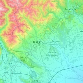
Name: Biella topographic map, elevation, terrain.
Location: Biella, Piemont, Italy (45.37609 7.88146 45.75764 8.32791)
Average elevation: 668 m
Minimum elevation: 140 m
Maximum elevation: 3,061 m
Other topographic maps
Click on a map to view its topography, its elevation and its terrain.
Orta San Giulio
Italy > Piemont > Orta San Giulio
Orta San Giulio, Novara, Piemont, 28016, Italy
Average elevation: 341 m
San Germano Vercellese
Italy > Piemont > San Germano Vercellese
San Germano Vercellese, Vercelli, Piemont, 13047, Italy
Average elevation: 163 m
Caselle Torinese
Italy > Piemont > Caselle Torinese
Caselle Torinese, TO, Piemont, Italy
Average elevation: 279 m
Grange Vernet
Italy > Piemont > Grange Vernet
Grange Vernet, TO, Piemont, 10052, Italy
Average elevation: 1,669 m
Western Alps
Italy > Piemont > Ceppo Morelli
Western Alps, Ceppo Morelli, VB, Piemont, 28876, Italy
Average elevation: 2,662 m
Lake Maggiore
Lake Maggiore, Corso Belvedere, Ghiffa, VB, Piemont, 28823, Italy
Average elevation: 655 m
Ghiacciaio del Belvedere
Ghiacciaio del Belvedere, bivacco Marinelli, Macugnaga, VB, Piemont, Italy
Average elevation: 2,971 m