
County Mayo topographic map
Click on the map to display elevation.
About this map
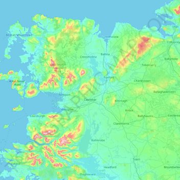
Name: County Mayo topographic map, elevation, terrain.
Location: County Mayo, Connacht, Ireland (53.47193 -10.32256 54.34542 -8.58283)
Average elevation: 66 m
Minimum elevation: -2 m
Maximum elevation: 765 m
Ireland trails, hiking, mountain biking, running and outdoor activities
Other topographic maps
Click on a map to view its topography, its elevation and its terrain.
Ballyhaise
Ballyhaise Bridge was built around 1710 by Colonel Brockhill Newburgh. It is made from roughly coursed limestone elevations which have elliptical arches having cut-stone arch rings. The bridge was positioned on a central axis with Ballyhaise House, which acts as a reminder of the formally laid out demesne. Its…
Average elevation: 82 m
Swords
Ireland > County Dublin > Swords
The medieval town developed in a linear pattern along Main Street, in a roughly north-south direction. Swords has one of the best examples of this settlement pattern in the Dublin region. The round tower, 26m in height, is also an indicator of early Christian settlement. The Irish high king Brian Boru is said…
Average elevation: 28 m
Greystones
Greystones is located south of the site of an ancient castle of the Barony of Rathdown. There was a hamlet which, like Rathdown Castle, was known as Rathdown, and which appeared on a 1712 map. This site occupied an area now known as the Grove, north of Greystones harbour, but only the ruins of a chapel, St.…
Average elevation: 49 m