
Graz topographic map
Interactive map
Click on the map to display elevation.
About this map
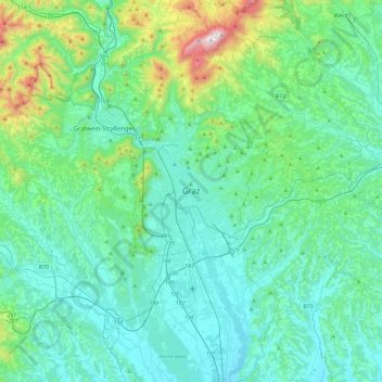
Name: Graz topographic map, elevation, terrain.
Location: Graz, Styria, 8011, Austria (46.91026 15.27857 47.23026 15.59857)
Average elevation: 481 m
Minimum elevation: 299 m
Maximum elevation: 1,443 m
Other topographic maps
Click on a map to view its topography, its elevation and its terrain.
Graz
Graz is situated on both sides of the Mur river in southeast Austria. It is about 150 km (93 mi) southwest of Vienna (Wien). The nearest larger urban centre is Maribor (Marburg) in Slovenia, which is about 50 km (31 mi) to the south. Graz is the state capital and largest city in Styria, a green and heavily…
Average elevation: 426 m