
Make a donation
Gear up for your next adventure:
As an Amazon Associate, this site earns from qualifying purchases at no extra cost to you.
Graz topographic map
Click on the map to display elevation.
Make a donation
Gear up for your next adventure:
As an Amazon Associate, this site earns from qualifying purchases at no extra cost to you.
Graz
Graz is situated on both sides of the Mur river in southeast Austria. It is about 150 km (93 mi) southwest of Vienna (Wien). The nearest larger urban centre is Maribor (Marburg) in Slovenia, which is about 50 km (31 mi) to the south. Graz is the state capital and largest city in Styria, a green and heavily forested region on the eastern edge of the Alps. It is located in the Graz Basin and surrounded by mountains and hills to the north, east and west. The city center sits at an elevation of 353 m (1,158 ft), the highest point is Plabutsch mountain with 754 m (2,474 ft) at the western border. The mountain Schöckl is just a few kilometers to the north and surmounts the city by 1,100 m (3,600 ft).
Make a donation
Gear up for your next adventure:
As an Amazon Associate, this site earns from qualifying purchases at no extra cost to you.
About this map
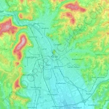
Name: Graz topographic map, elevation, terrain.
Location: Graz, Styria, Austria (47.01189 15.34971 47.13450 15.53420)
Average elevation: 426 m
Minimum elevation: 326 m
Maximum elevation: 749 m
Make a donation
Gear up for your next adventure:
As an Amazon Associate, this site earns from qualifying purchases at no extra cost to you.