
Langsa topographic map
Interactive map
Click on the map to display elevation.
About this map
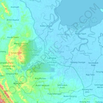
Name: Langsa topographic map, elevation, terrain.
Location: Langsa, Aceh, Indonesia (4.40653 97.89754 4.56276 98.08446)
Average elevation: 15 m
Minimum elevation: -4 m
Maximum elevation: 163 m
Other topographic maps
Click on a map to view its topography, its elevation and its terrain.
Meureubo
Indonesia > Aceh > Aceh Barat
Meureubo, Aceh Barat, Aceh, 23615, Indonesia
Average elevation: 9 m
Gunung Babahrot
Gunung Babahrot, Babah Rot, Aceh Barat Daya, Aceh, Indonesia
Average elevation: 157 m
Gunung Bandahara
Gunung Bandahara, Putri Betung, Gayo Lues, Aceh, Indonesia
Average elevation: 2,634 m
Gunung Mugajah
Gunung Mugajah, Serbajadi, Aceh Timur, Aceh, Indonesia
Average elevation: 2,189 m