
Gdańsk topographic map
Interactive map
Click on the map to display elevation.
About this map
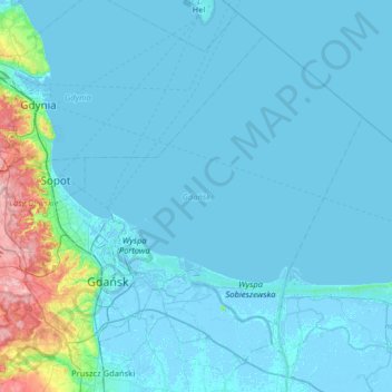
Name: Gdańsk topographic map, elevation, terrain.
Location: Gdańsk, Pomeranian Voivodeship, Poland (54.27492 18.42950 54.58273 19.07030)
Average elevation: 13 m
Minimum elevation: -5 m
Maximum elevation: 168 m
Other topographic maps
Click on a map to view its topography, its elevation and its terrain.
Gardeja
Poland > Pomeranian Voivodeship > Kwidzyn County
Gardeja, gmina Gardeja, Kwidzyn County, Pomeranian Voivodeship, Poland
Average elevation: 90 m
Ustka
Poland > Pomeranian Voivodeship > Słupsk County > Ustka
Ustka, Słupsk County, Pomeranian Voivodeship, Poland
Average elevation: 6 m
Gdynia
Poland > Pomeranian Voivodeship > Gdynia
Gdynia, Pomeranian Voivodeship, Poland
Average elevation: 51 m
Luboń
Poland > Pomeranian Voivodeship > Luboń
Luboń, gmina Lipnica, powiat bytowski, Pomeranian Voivodeship, 77-130, Poland
Average elevation: 161 m