
Thank you for supporting this site ❤️
Make a donation
Make a donation
Gear up for your next adventure:
As an Amazon Associate, this site earns from qualifying purchases at no extra cost to you.
Cikuray topographic map
Click on the map to display elevation.
Thank you for supporting this site ❤️
Make a donation
Make a donation
Gear up for your next adventure:
As an Amazon Associate, this site earns from qualifying purchases at no extra cost to you.
About this map
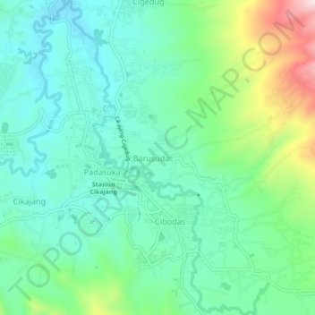
Name: Cikuray topographic map, elevation, terrain.
Location: Cikuray, Barusuda, Garut, West Java, Java, Indonesia (-7.37493 107.79880 -7.33196 107.82705)
Average elevation: 1,289 m
Minimum elevation: 1,176 m
Maximum elevation: 1,596 m
Thank you for supporting this site ❤️
Make a donation
Make a donation
Gear up for your next adventure:
As an Amazon Associate, this site earns from qualifying purchases at no extra cost to you.