
Guadalupe Mountains National Park topographic map
Interactive map
Click on the map to display elevation.
Guadalupe Mountains National Park
The Guadalupe Mountains reach their highest point at Guadalupe Peak, the highest point in Texas, with an elevation of 8,751 feet (2,667 m). The range lies southeast of the Sacramento Mountains and east of the Brokeoff Mountains. The mountain range extends north-northwest and northeast from Guadalupe Peak in Texas into New Mexico. The northeastern extension ends about 10 miles (16 km) southwest of Carlsbad, near Carlsbad Caverns National Park; the southwest tip ends with El Capitan about 90 miles (140 km) east of El Paso. The mountains rise more than 3,000 feet (910 m) above the arid floor of the Chihuahuan Desert. The Guadalupe Mountains are surrounded by the South Plains to the east and north, Delaware Mountains to the south, and Sacramento Mountains to the west.
About this map
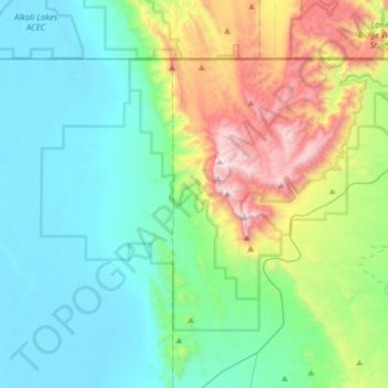
Name: Guadalupe Mountains National Park topographic map, elevation, terrain.
Average elevation: 1,484 m
Minimum elevation: 1,100 m
Maximum elevation: 2,650 m