
Thank you for supporting this site ❤️
Make a donation
Make a donation
Gear up for your next adventure:
As an Amazon Associate, this site earns from qualifying purchases at no extra cost to you.
Arnold topographic map
Click on the map to display elevation.
Thank you for supporting this site ❤️
Make a donation
Make a donation
Gear up for your next adventure:
As an Amazon Associate, this site earns from qualifying purchases at no extra cost to you.
About this map
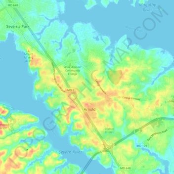
Name: Arnold topographic map, elevation, terrain.
Location: Arnold, Anne Arundel County, Maryland, 21012, United States (39.00644 -76.54527 39.07801 -76.44187)
Average elevation: 14 m
Minimum elevation: -3 m
Maximum elevation: 49 m
Thank you for supporting this site ❤️
Make a donation
Make a donation
Gear up for your next adventure:
As an Amazon Associate, this site earns from qualifying purchases at no extra cost to you.
Other topographic maps
Click on a map to view its topography, its elevation and its terrain.
Winchester-on-the-Severn
United States > Maryland > Anne Arundel County > Arnold
Average elevation: 16 m