
Make a donation
Gear up for your next adventure:
As an Amazon Associate, this site earns from qualifying purchases at no extra cost to you.
Burg Ramsberg topographic map
Click on the map to display elevation.
Make a donation
Gear up for your next adventure:
As an Amazon Associate, this site earns from qualifying purchases at no extra cost to you.
Burg Ramsberg
Heute befindet sich an der einstigen Burgstelle eine Einsiedelei. Die Burgkapelle stammt vermutlich noch aus romanischer Zeit. Die Kapelle geht im baulichen Bestand bis in die hochmittelalterliche Burganlage (11. Jahrhundert) der Grafen von Ramsberg und Pfullendorf zurück. Sie ist der Sockel des Bergfrieds, der sich jedoch in mindestens doppelter Höhe erhob. Dass sich in diesem Burgturm bereits eine Kapelle befand, ist möglich, jedoch nicht gesichert.
Make a donation
Gear up for your next adventure:
As an Amazon Associate, this site earns from qualifying purchases at no extra cost to you.
About this map
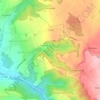
Name: Burg Ramsberg topographic map, elevation, terrain.
Average elevation: 635 m
Minimum elevation: 539 m
Maximum elevation: 730 m
Make a donation
Gear up for your next adventure:
As an Amazon Associate, this site earns from qualifying purchases at no extra cost to you.