
安达市 topographic map
Interactive map
Click on the map to display elevation.
About this map
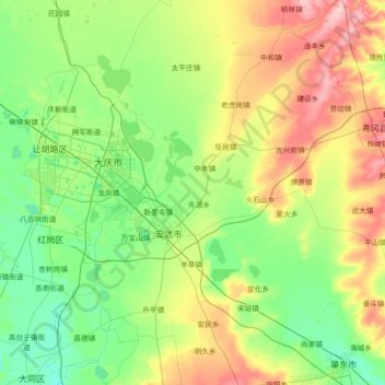
Name: 安达市 topographic map, elevation, terrain.
Location: 安达市, 绥化市 / Suihua, Heilongjiang, China (46.01500 124.87025 47.01102 125.91217)
Average elevation: 160 m
Minimum elevation: 131 m
Maximum elevation: 245 m
Other topographic maps
Click on a map to view its topography, its elevation and its terrain.
松花江
China > Heilongjiang > Harbin
松花江, 宾县, Harbin, Heilongjiang, 132011, China
Average elevation: 310 m