
Make a donation
Gear up for your next adventure:
As an Amazon Associate, this site earns from qualifying purchases at no extra cost to you.
Ludlow topographic map
Click on the map to display elevation.
Make a donation
Gear up for your next adventure:
As an Amazon Associate, this site earns from qualifying purchases at no extra cost to you.
About this map
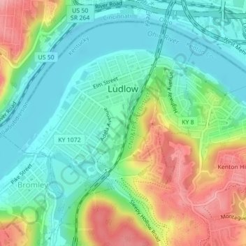
Name: Ludlow topographic map, elevation, terrain.
Location: Ludlow, Kenton County, Kentucky, 41016, United States (39.07764 -84.56454 39.09992 -84.53693)
Average elevation: 182 m
Minimum elevation: 138 m
Maximum elevation: 262 m
Make a donation
Gear up for your next adventure:
As an Amazon Associate, this site earns from qualifying purchases at no extra cost to you.
Other topographic maps
Click on a map to view its topography, its elevation and its terrain.
Make a donation
Gear up for your next adventure:
As an Amazon Associate, this site earns from qualifying purchases at no extra cost to you.
Sunny Acres
United States > Kentucky > Kenton County > Taylor Mill > Sunny Acres
Average elevation: 216 m