
Thank you for supporting this site ❤️
Make a donation
Make a donation
Gear up for your next adventure:
As an Amazon Associate, this site earns from qualifying purchases at no extra cost to you.
Sende topographic map
Click on the map to display elevation.
Thank you for supporting this site ❤️
Make a donation
Make a donation
Gear up for your next adventure:
As an Amazon Associate, this site earns from qualifying purchases at no extra cost to you.
Sende
Sende liegt auf einer Höhe von 110 m ü. NN am Westrand der Senne südwestlich des Teutoburger Waldes.
Thank you for supporting this site ❤️
Make a donation
Make a donation
Gear up for your next adventure:
As an Amazon Associate, this site earns from qualifying purchases at no extra cost to you.
About this map
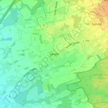
Name: Sende topographic map, elevation, terrain.
Location: Sende, Verl, Kreis Gütersloh, Nordrhein-Westfalen, Deutschland (51.88635 8.53244 51.92635 8.57244)
Average elevation: 104 m
Minimum elevation: 92 m
Maximum elevation: 121 m
Thank you for supporting this site ❤️
Make a donation
Make a donation
Gear up for your next adventure:
As an Amazon Associate, this site earns from qualifying purchases at no extra cost to you.