
Xiahe topographic map
Interactive map
Click on the map to display elevation.
About this map
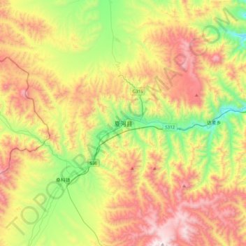
Name: Xiahe topographic map, elevation, terrain.
Average elevation: 3,366 m
Minimum elevation: 2,704 m
Maximum elevation: 4,203 m
Xiahe (Sangqu) is found in the southern portion of Gansu province, along the western border with Qinghai province. It lies along the Daxia and Zhao rivers. It is on the northeast edge of the Tibetan Plateau. The average elevation is 2,900 to 3,100 m (9,500 to 10,200 ft) with the highest being 4,636 m (15,210 ft) and the lowest 2,160 m (7,087 ft).