
Make a donation
Gear up for your next adventure:
As an Amazon Associate, this site earns from qualifying purchases at no extra cost to you.
Beypore topographic map
Click on the map to display elevation.
Make a donation
Gear up for your next adventure:
As an Amazon Associate, this site earns from qualifying purchases at no extra cost to you.
Beypore
Beypore is located at 11°11′N 75°49′E / 11.18°N 75.82°E / 11.18; 75.82. It has an average elevation of one metre (3 ft 3 in).
Make a donation
Gear up for your next adventure:
As an Amazon Associate, this site earns from qualifying purchases at no extra cost to you.
About this map
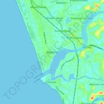
Name: Beypore topographic map, elevation, terrain.
Location: Beypore, Kozhikode, Kozhikode district, Kerala, 673015, India (11.13907 75.77018 11.21907 75.85018)
Average elevation: 8 m
Minimum elevation: -2 m
Maximum elevation: 57 m
Make a donation
Gear up for your next adventure:
As an Amazon Associate, this site earns from qualifying purchases at no extra cost to you.
Other topographic maps
Click on a map to view its topography, its elevation and its terrain.