Geolocate

Rantau Panjang topographic map

Interactive map

Click on the map to display elevation.

About this map

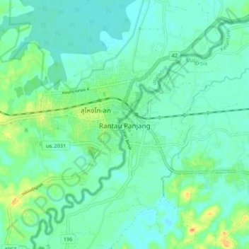
Name: Rantau Panjang topographic map, elevation, terrain.

Location: Rantau Panjang, Pasir Mas, Kelantan, 17200, Malaysia (5.97812 101.93282 6.05812 102.01282)

Average elevation: 12 m

Minimum elevation: 2 m

Maximum elevation: 41 m

Other topographic maps

Click on a map to view its topography, its elevation and its terrain.

Taman Tengku Anis

Malaysia > Kelantan > Kota Bharu

Average elevation: 8 m

Kemubu Island

Malaysia > Kelantan > Kemubu

Average elevation: 68 m

Tumpat

Malaysia > Kelantan

Average elevation: 5 m

Sungai Jedok

Malaysia > Kelantan > Batu Gajah

Average elevation: 45 m

Sungai Sokor

Malaysia > Kelantan

Average elevation: 117 m

Jeli

Malaysia > Kelantan

Average elevation: 494 m

Nenggiri River

Malaysia > Kelantan

Average elevation: 111 m

Galas River

Malaysia > Kelantan > Dabong

Average elevation: 297 m

Galas River

Malaysia > Kelantan

Average elevation: 305 m

Sungai Chenderoh

Malaysia > Kelantan

Average elevation: 303 m

Pulau Raya

Malaysia > Kelantan > Tanah Merah

Average elevation: 18 m

Pasir Puteh

Malaysia > Kelantan

Average elevation: 57 m

Sungai Rasau

Malaysia > Kelantan > Kampung Bukit

Average elevation: 98 m

Sungai Durian

Malaysia > Kelantan

Average elevation: 32 m

Sungai Chenderoh

Malaysia > Kelantan

Average elevation: 311 m

Sungai Pertang

Malaysia > Kelantan

Average elevation: 101 m

Sungai Sokor

Malaysia > Kelantan

Average elevation: 41 m

Pantai Tok Bali

Malaysia > Kelantan > Tok Bali

Average elevation: 3 m

Pergau Dam

Malaysia > Kelantan

Average elevation: 634 m

Kolok River

Malaysia > Kelantan > Rantau Panjang

Average elevation: 79 m

Sungai Long

Malaysia > Kelantan > Sungai Long

Average elevation: 404 m

Pasir Mas

Malaysia > Kelantan

Average elevation: 12 m

Sungai Lubuk Mulong

Malaysia > Kelantan > Kota Bharu

Average elevation: 10 m

Kuala Krai

Malaysia > Kelantan

Kuala Krai (alternative spelling: Kuala Kerai, Jawi: كوالا كراي) is a town located in the coterminous Kuala Krai District in southern-central Kelantan, Malaysia. During British protection it was known as Kuala Lebir. It is 67 km from state capital Kota Bharu and 273 km from national capital Kuala…

Average elevation: 249 m

Sungai Teku

Malaysia > Kelantan

Average elevation: 76 m

Sungai Mering

Malaysia > Kelantan

Average elevation: 435 m

Sungai Nenggiri

Malaysia > Kelantan > Kuala Betis

Average elevation: 285 m

Lojing

Malaysia > Kelantan

Average elevation: 735 m

Sungai Mulong

Malaysia > Kelantan

Average elevation: 9 m

Sungai Semerak

Malaysia > Kelantan

Average elevation: 7 m

Kelantan River

Malaysia > Kelantan > Kampung Paloh

The river's tributaries rise in the forested mountains in the Gua Musang region in southern Kelantan, where many Orang Asli tribes live. The area is known for its karst topography, dotted with mogotes with numerous caves beneath them. Some cave systems along the Nenggiri River, the river's left tributary, show…

Average elevation: 71 m

Gua Musang

Malaysia > Kelantan

Average elevation: 448 m

Pantai Irama

Malaysia > Kelantan > Bachok

Average elevation: 4 m

Tanah Merah

Malaysia > Kelantan

Average elevation: 95 m

Sungai Temiang

Malaysia > Kelantan

Average elevation: 116 m

Sungai Nal

Malaysia > Kelantan

Average elevation: 65 m

Sungai Kelar

Malaysia > Kelantan > Pasir Mas

Average elevation: 12 m

Bachok

Malaysia > Kelantan

Average elevation: 6 m

Sungai Betis

Malaysia > Kelantan > Kuala Betis

Average elevation: 280 m

Machang

Malaysia > Kelantan

Average elevation: 93 m

Sungai Nibong

Malaysia > Kelantan

Average elevation: 26 m

Kelantan River

Malaysia > Kelantan

The river's tributaries rise in the forested mountains in the Gua Musang region in southern Kelantan, where many Orang Asli tribes live. The area is known for its karst topography, dotted with mogotes with numerous caves beneath them. Some cave systems along the Nenggiri River, the river's left tributary, show…

Average elevation: 71 m

Sungai Jeram

Malaysia > Kelantan

Average elevation: 37 m