
Make a donation
Gear up for your next adventure:
As an Amazon Associate, this site earns from qualifying purchases at no extra cost to you.
Mont Noir topographic map
Click on the map to display elevation.
Make a donation
Gear up for your next adventure:
As an Amazon Associate, this site earns from qualifying purchases at no extra cost to you.
Mont Noir
Le mont Noir (Zwarteberg en flamand) est une colline culminant à 152 m d'altitude dans les monts des Flandres à quelques centaines de mètres de la frontière franco-belge et à quelques kilomètres de Bailleul. Il tire son nom de la présence d'une forte concentration du pin noir dans le bois qui couvre ce relief. Le mont est à la frontière entre la Belgique et la France et dépend de la commune de Saint-Jans-Cappel.
Make a donation
Gear up for your next adventure:
As an Amazon Associate, this site earns from qualifying purchases at no extra cost to you.
About this map
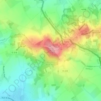
Name: Mont Noir topographic map, elevation, terrain.
Average elevation: 78 m
Minimum elevation: 29 m
Maximum elevation: 151 m
Make a donation
Gear up for your next adventure:
As an Amazon Associate, this site earns from qualifying purchases at no extra cost to you.
Other topographic maps
Click on a map to view its topography, its elevation and its terrain.