
Make a donation
Gear up for your next adventure:
As an Amazon Associate, this site earns from qualifying purchases at no extra cost to you.
Schaufenberg topographic map
Click on the map to display elevation.
Make a donation
Gear up for your next adventure:
As an Amazon Associate, this site earns from qualifying purchases at no extra cost to you.
Schaufenberg
Schaufenberg liegt an einem Hang („Kobbendahler Höhe“) oberhalb des Tals des Golkrather Baches in einer Höhenlage von ca. 60–70 m.ü.NN. Östlich des Ortes befindet sich am „Kantinenberg“ die älteste Abraumhalde der Zeche Sophia-Jacoba.
Make a donation
Gear up for your next adventure:
As an Amazon Associate, this site earns from qualifying purchases at no extra cost to you.
About this map
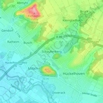
Name: Schaufenberg topographic map, elevation, terrain.
Average elevation: 68 m
Minimum elevation: 41 m
Maximum elevation: 150 m
Make a donation
Gear up for your next adventure:
As an Amazon Associate, this site earns from qualifying purchases at no extra cost to you.
Other topographic maps
Click on a map to view its topography, its elevation and its terrain.
41836
Deutschland > Nordrhein-Westfalen > Kreis Heinsberg > Hückelhoven > Doveren > Doverheide
Average elevation: 56 m