
Make a donation
Gear up for your next adventure:
As an Amazon Associate, this site earns from qualifying purchases at no extra cost to you.
Siptenfelde topographic map
Click on the map to display elevation.
Make a donation
Gear up for your next adventure:
As an Amazon Associate, this site earns from qualifying purchases at no extra cost to you.
Siptenfelde
Alexisbad mit Hänichen und Klostermühle | Dankerode | Stadt Güntersberge mit Bärenrode und Friedrichshöhe | Harzgerode | Königerode | Mägdesprung | Neudorf | Schielo | Silberhütte | Siptenfelde | Straßberg mit Lindenberg
Make a donation
Gear up for your next adventure:
As an Amazon Associate, this site earns from qualifying purchases at no extra cost to you.
About this map
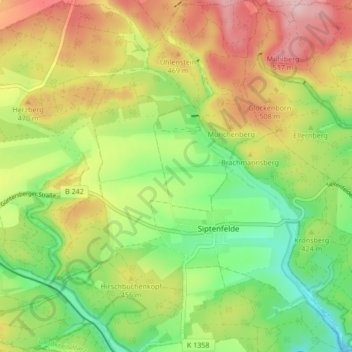
Name: Siptenfelde topographic map, elevation, terrain.
Average elevation: 432 m
Minimum elevation: 342 m
Maximum elevation: 541 m
Make a donation
Gear up for your next adventure:
As an Amazon Associate, this site earns from qualifying purchases at no extra cost to you.
Other topographic maps
Click on a map to view its topography, its elevation and its terrain.
Silberhütte
Deutschland > Sachsen-Anhalt > Landkreis Harz > Harzgerode
Alexisbad mit Hänichen und Klostermühle | Dankerode | Stadt Güntersberge mit Bärenrode und Friedrichshöhe | Harzgerode | Königerode | Mägdesprung | Neudorf | Schielo | Silberhütte | Siptenfelde | Straßberg mit Lindenberg
Average elevation: 396 m
Make a donation
Gear up for your next adventure:
As an Amazon Associate, this site earns from qualifying purchases at no extra cost to you.