
Make a donation
Gear up for your next adventure:
As an Amazon Associate, this site earns from qualifying purchases at no extra cost to you.
Avadi topographic map
Click on the map to display elevation.
Make a donation
Gear up for your next adventure:
As an Amazon Associate, this site earns from qualifying purchases at no extra cost to you.
Avadi
Avadi is located at 13°07′N 80°06′E / 13.12°N 80.1°E / 13.12; 80.1. It covers an area of 65 square kilometres (25 sq mi) and has an average elevation of 17 metres (56 ft).
Make a donation
Gear up for your next adventure:
As an Amazon Associate, this site earns from qualifying purchases at no extra cost to you.
About this map
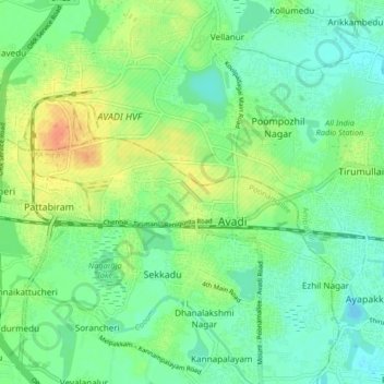
Name: Avadi topographic map, elevation, terrain.
Location: Avadi, Poonamallee, Thiruvallur, Tamil Nadu, 600054, India (12.95948 79.94267 13.27948 80.26267)
Average elevation: 23 m
Minimum elevation: -1 m
Maximum elevation: 137 m
Make a donation
Gear up for your next adventure:
As an Amazon Associate, this site earns from qualifying purchases at no extra cost to you.
Other topographic maps
Click on a map to view its topography, its elevation and its terrain.