
Make a donation
Gear up for your next adventure:
As an Amazon Associate, this site earns from qualifying purchases at no extra cost to you.
Keranot topographic map
Click on the map to display elevation.
Make a donation
Gear up for your next adventure:
As an Amazon Associate, this site earns from qualifying purchases at no extra cost to you.
About this map
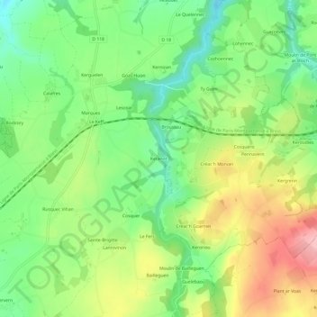
Name: Keranot topographic map, elevation, terrain.
Average elevation: 134 m
Minimum elevation: 72 m
Maximum elevation: 219 m
Make a donation
Gear up for your next adventure:
As an Amazon Associate, this site earns from qualifying purchases at no extra cost to you.
Other topographic maps
Click on a map to view its topography, its elevation and its terrain.
Loc-Eguiner-Saint-Thégonnec
France > Bretagne > Finistère > Saint-Thégonnec Loc-Eguiner
Longée par le fleuve côtier la Penzé, qui sert de limite communale avec Saint-Sauveur, la commune de Loc-Eguiner-Saint-Thégonnec a une altitude comprise entre 83 et 181 mètres d'altitude, le bourg se trouvant vers 110 mètres.
Average elevation: 142 m