
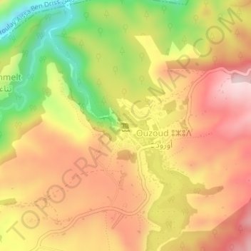
Cascades d'Ouzoud topographic map
Interactive map
Click on the map to display elevation.
About this map
Name: Cascades d'Ouzoud topographic map, elevation, terrain.
Average elevation: 783 m
Minimum elevation: 574 m
Maximum elevation: 937 m
Les cascades d'Ouzoud (en amazigh. imuzzar n Uzud, en arabe. شلالات أوزود) sont des chutes d'eau d'environ 110 m de haut, sur trois paliers, sur un site géologique pittoresque de l'oued Tissakht, à 1060 m d'altitude du massif de l'Atlas, dans le Haut Atlas central, au Maroc. Ce vaste site est un important lieu touristique marocain, à 30 km d'Azilal, 120 km de Béni Mellal, et 150 km au nord-est de Marrakech.
Other topographic maps
Click on a map to view its topography, its elevation and its terrain.
Ouzoud
Maroc > cercle de Bzou > Ouzoud
Ouzoud, Ait Taguella, caïdat de Tanant, cercle de Bzou, Province d'Azilal, Béni Mellal-Khénifra, Maroc
Average elevation: 841 m